Pirojpur geodata
Pirojpur (Barisāl) is a populated place; located in Bangladesh in Asia/Dhaka (GMT+6) time zone. With population of 54,418 people, there are 58 cities with bigger population in this country. Compared to other cities in Bangladesh, 87.2% of cities are located further ↑North; 54.7% of cities are located further →East and 81.2% of cities have higher elevation than Pirojpur. Note1
Administrative division(s):
- Level 1: Barisāl
- Level 2: Pirojpur
- Level 3: Pirojpur S.
- Level 4: Paurashava


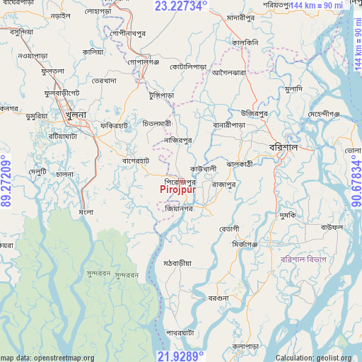
Pirojpur GPS coordinates[2]
22° 34' 46.74" North, 89° 58' 30.756" East
| Map corner | latitude | longitude |
|---|---|---|
| Upper-left | 23.22734°, | 89.27209° |
| Center: | 22.57965°, | 89.97521° |
| Lower-right: | 21.9289°, | 90.67834° |
| Map W x H: | 144.4×144.4 km | = 89.7×89.7mi |
| max Lat: | 26.33338° ⇑87.2% North |
| Pirojpur: | 22.57965° |
| min Lat: | ⇓12.8% South 20.85829° |
| min Long | Pirojpur | max Long |
| 88.15638° | 89.97521° | 92.29773° |
| W 45.3%⇐ | ⇒54.7% E |
Elevation
Elevation of Pirojpur is 10 m = 33 ft, and this is 7.9 m = 26 ft below average elevation for this country.
| Max E: |
79 m = 259 ft | 81.2% |
| Avg. | 17.9 m = 59 ft | |
| Pirojpur | 10 m = 33 ft | |
Min E: |
2 m = 7 ft | 18.8% |
See also: Pirojpur elevation on elevation.city.
Geographical zone
Pirojpur is located in North Torrid zone (between Equator and Tropic of Cancer). Distance of this Northern Tropic circle is 95.3 km =59.2 mi to North.| Distance of | km | miles | from Pirojpur |
|---|---|---|---|
| North Pole | 7496.4 | 4658 | to North |
| Arctic Circle | 4890.6 | 3038.9 | to North |
| Tropic Cancer | 95.3 | 59.2 | to North |
| Equator | 2510.6 | 1560 | to South |


Nearby cities:
15 places around Pirojpur: (largest is in red/bold)
• Bagerhat
20.7 km =12.9 mi,  294°
294°
• Barisāl
42.9 km =26.7 mi,  71°
71°
• Bhola
69.7 km =43.3 mi,  80°
80°
• Bhāndāria
13.5 km =8.4 mi,  138°
138°
• Gaurnadi
50.7 km =31.5 mi,  30°
30°
• Khulna
49.3 km =30.6 mi,  301°
301°
• Kālia
62.4 km =38.8 mi,  325°
325°
• Mathba
32.7 km =20.3 mi,  182°
182°
• Mehendiganj
62.9 km =39.1 mi,  64°
64°
• Morrelgonj
18.4 km =11.4 mi,  221°
221°
• Mādārīpur
70 km =43.5 mi,  20°
20°
• Nālchiti
31.1 km =19.3 mi, 78°
• Phultala
49.9 km =31 mi, 287°
• Sarankhola
35.4 km =22 mi,  212°
212°
• Tungipāra
36.4 km =22.6 mi,  348°
348°
Sources, notices
• [Note1] Compared only with cities in Bangladesh existing in our database
• [Src1] Map data: © OpenStreetMap contributors (CC-BY-SA)
• [Src2] Other city data from geonames.org with taken over terms of usage.
• [Src3] Geographical zone / Annual Mean Temperature by Robert A. Rohde @ Wikipedia
