Jamālpur geodata
Jamālpur (Mymensingh Division) is a seat of a second-order administrative division; located in Bangladesh in Asia/Dhaka (GMT+6) time zone. With population of 167,900 people, there are 25 cities with bigger population in this country. Compared to other cities in Bangladesh, 83.8% of cities are located further ↓South; 56.4% of cities are located further →East and 76.9% of cities have lower elevation than Jamālpur. Note1
Administrative division(s):
- Level 1: Mymensingh Division
- Level 2: Jamalpur
- Level 3: Jamalpur Upazila
- Level 4: Paurashava


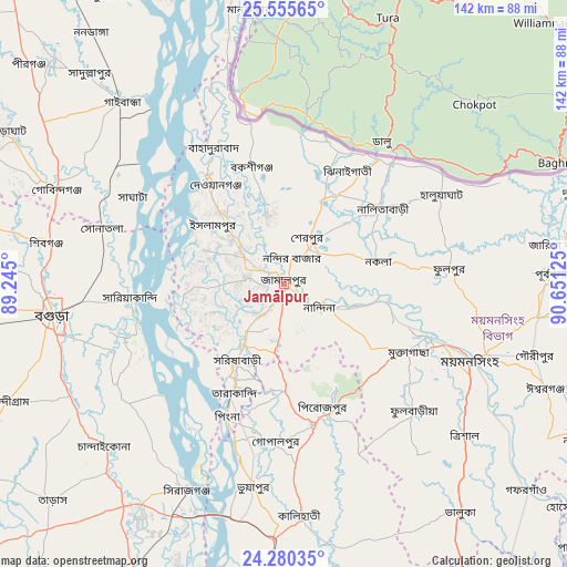
Jamālpur GPS coordinates[2]
24° 55' 10.74" North, 89° 56' 53.232" East
| Map corner | latitude | longitude |
|---|---|---|
| Upper-left | 25.55565°, | 89.245° |
| Center: | 24.91965°, | 89.94812° |
| Lower-right: | 24.28035°, | 90.65125° |
| Map W x H: | 141.8×141.8 km | = 88.1×88.1mi |
| max Lat: | 26.33338° ⇑16.2% North |
| Jamālpur: | 24.91965° |
| min Lat: | ⇓83.8% South 20.85829° |
| min Long | Jamālpur | max Long |
| 88.15638° | 89.94812° | 92.29773° |
| W 43.6%⇐ | ⇒56.4% E |
Elevation
Elevation of Jamālpur is 23 m = 75 ft, and this is 5.1 m = 17 ft above average elevation for this country.
| Max E: |
79 m = 259 ft | 23.1% |
| Jamālpur | 23 m 75 ft | |
| Avg. | 17.9 m = 59 ft | |
Min E: |
2 m = 7 ft | 76.9% |
See also: Jamālpur elevation on elevation.city.
Geographical zone
Jamālpur is located in North temperate zone (between Tropic of Cancer and the Arctic Circle). Distance of this Northern Tropic circle is 164.9 km =102.5 mi to South.| Distance of | km | miles | from Jamālpur |
|---|---|---|---|
| North Pole | 7236.3 | 4496.4 | to North |
| Arctic Circle | 4630.4 | 2877.2 | to North |
| Tropic Cancer | 164.9 | 102.5 | to South |
| Equator | 2770.8 | 1721.7 | to South |


Nearby cities:
15 places around Jamālpur: (largest is in red/bold)
• Bogra
58.7 km =36.5 mi,  262°
262°
• Chilmāri
76.1 km =47.3 mi,  338°
338°
• Gafargaon
82.1 km =51 mi,  131°
131°
• Gaibandha
61.1 km =38 mi,  318°
318°
• Mahasthangarh
61.2 km =38 mi,  274°
274°
• Muktāgācha
35.6 km =22.1 mi,  118°
118°
• Mymensingh
49.7 km =30.9 mi,  111°
111°
• Netrakona
78.9 km =49 mi,  92°
92°
• Purbadhala
65.8 km =40.9 mi, 87°
• Sakhipur
70.3 km =43.7 mi,  161°
161°
• Sarishābāri
22.1 km =13.7 mi,  212°
212°
• Sherpur
13.1 km =8.1 mi,  32°
32°
• Shibganj
63.7 km =39.6 mi,  278°
278°
• Sirajganj
56.8 km =35.3 mi, 205°
• Tāngāil
74.5 km =46.3 mi,  182°
182°
Sources, notices
• [Note1] Compared only with cities in Bangladesh existing in our database
• [Src1] Map data: © OpenStreetMap contributors (CC-BY-SA)
• [Src2] Other city data from geonames.org with taken over terms of usage.
• [Src3] Geographical zone / Annual Mean Temperature by Robert A. Rohde @ Wikipedia
