Sherpur geodata
Sherpur (Mymensingh Division) is a populated place; located in Bangladesh in Asia/Dhaka (GMT+6) time zone. With population of 107,419 people, there are 33 cities with bigger population in this country. Compared to other cities in Bangladesh, 87.2% of cities are located further ↓South; 53.8% of cities are located further →East and 82.9% of cities have lower elevation than Sherpur. Note1
Administrative division(s):
- Level 1: Mymensingh Division
- Level 2: Sherpur
- Level 3: Sherpur Sadar Upazila
- Level 4: Paurashava


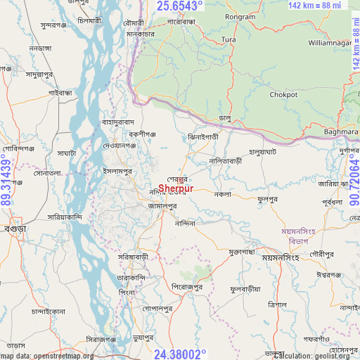
Sherpur GPS coordinates[2]
25° 1' 7.716" North, 90° 1' 3.036" East
| Map corner | latitude | longitude |
|---|---|---|
| Upper-left | 25.6543°, | 89.31439° |
| Center: | 25.01881°, | 90.01751° |
| Lower-right: | 24.38002°, | 90.72064° |
| Map W x H: | 141.7×141.7 km | = 88×88mi |
| max Lat: | 26.33338° ⇑12.8% North |
| Sherpur: | 25.01881° |
| min Lat: | ⇓87.2% South 20.85829° |
| min Long | Sherpur | max Long |
| 88.15638° | 90.01751° | 92.29773° |
| W 46.2%⇐ | ⇒53.8% E |
Elevation
Elevation of Sherpur is 25 m = 82 ft, and this is 7.1 m = 23 ft above average elevation for this country.
| Max E: |
79 m = 259 ft | 17.1% |
| Sherpur | 25 m 82 ft | |
| Avg. | 17.9 m = 59 ft | |
Min E: |
2 m = 7 ft | 82.9% |
See also: Sherpur elevation on elevation.city.
Geographical zone
Sherpur is located in North temperate zone (between Tropic of Cancer and the Arctic Circle). Distance of this Northern Tropic circle is 175.9 km =109.3 mi to South.| Distance of | km | miles | from Sherpur |
|---|---|---|---|
| North Pole | 7225.2 | 4489.5 | to North |
| Arctic Circle | 4619.3 | 2870.3 | to North |
| Tropic Cancer | 175.9 | 109.3 | to South |
| Equator | 2781.8 | 1728.5 | to South |


Nearby cities:
15 places around Sherpur: (largest is in red/bold)
• Bogra
67.8 km =42.1 mi,  254°
254°
• Chilmāri
69.2 km =43 mi,  329°
329°
• Gafargaon
85.1 km =52.9 mi,  140°
140°
• Gaibandha
58.9 km =36.6 mi,  305°
305°
• Jamālpur
13.1 km =8.1 mi,  212°
212°
• Mahasthangarh
68.3 km =42.4 mi,  264°
264°
• Muktāgācha
37.2 km =23.1 mi, 139°
• Mymensingh
48.9 km =30.4 mi,  126°
126°
• Netrakona
73.3 km =45.5 mi,  101°
101°
• Purbadhala
59.4 km =36.9 mi, 98°
• Sakhipur
79.2 km =49.2 mi,  168°
168°
• Sarishābāri
35.2 km =21.9 mi, 212°
• Shibganj
70 km =43.5 mi,  268°
268°
• Sirajganj
69.8 km =43.4 mi, 206°
• Tāngāil
86.1 km =53.5 mi,  186°
186°
Sources, notices
• [Note1] Compared only with cities in Bangladesh existing in our database
• [Src1] Map data: © OpenStreetMap contributors (CC-BY-SA)
• [Src2] Other city data from geonames.org with taken over terms of usage.
• [Src3] Geographical zone / Annual Mean Temperature by Robert A. Rohde @ Wikipedia
