Bhola geodata
Bhola (Barisāl) is a populated place; located in Bangladesh in Asia/Dhaka (GMT+6) time zone. With population of 99,079 people, there are 36 cities with bigger population in this country. Compared to other cities in Bangladesh, 83.8% of cities are located further ↑North; 70.9% of cities are located further ←West and 98.3% of cities have higher elevation than Bhola. Note1
Administrative division(s):
- Level 1: Barisāl
- Level 2: Bhola
- Level 3: Bhola Sadar Upazila
- Level 4: Paurashava


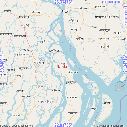
Bhola GPS coordinates[2]
22° 41' 15.324" North, 90° 38' 38.508" East
| Map corner | latitude | longitude |
|---|---|---|
| Upper-left | 23.33476°, | 89.94091° |
| Center: | 22.68759°, | 90.64403° |
| Lower-right: | 22.03735°, | 91.34716° |
| Map W x H: | 144.3×144.3 km | = 89.7×89.7mi |
| max Lat: | 26.33338° ⇑83.8% North |
| Bhola: | 22.68759° |
| min Lat: | ⇓16.2% South 20.85829° |
| min Long | Bhola | max Long |
| 88.15638° | 90.64403° | 92.29773° |
| W 70.9%⇐ | ⇒29.1% E |
Elevation
Elevation of Bhola is 7 m = 23 ft, and this is 10.9 m = 36 ft below average elevation for this country.
| Max E: |
79 m = 259 ft | 98.3% |
| Avg. | 17.9 m = 59 ft | |
| Bhola | 7 m = 23 ft | |
Min E: |
2 m = 7 ft | 1.7% |
See also: Bhola elevation on elevation.city.
Geographical zone
Bhola is located in North Torrid zone (between Equator and Tropic of Cancer). Distance of this Northern Tropic circle is 83.3 km =51.8 mi to North.| Distance of | km | miles | from Bhola |
|---|---|---|---|
| North Pole | 7484.4 | 4650.6 | to North |
| Arctic Circle | 4878.6 | 3031.4 | to North |
| Tropic Cancer | 83.3 | 51.8 | to North |
| Equator | 2522.6 | 1567.5 | to South |


Nearby cities:
15 places around Bhola: (largest is in red/bold)
• Barisāl
28.2 km =17.5 mi,  273°
273°
• Bhāndāria
63.6 km =39.5 mi,  249°
249°
• Burhānuddin
22.9 km =14.2 mi,  159°
159°
• Gaurnadi
53.5 km =33.2 mi,  306°
306°
• Hājīganj
66.4 km =41.3 mi,  19°
19°
• Lakshmīpur
34.3 km =21.3 mi,  33°
33°
• Lālmohan
40.1 km =24.9 mi,  166°
166°
• Mehendiganj
19.1 km =11.9 mi,  321°
321°
• Mādārīpur
69.8 km =43.4 mi, 320°
• Nālchiti
38.6 km =24 mi,  261°
261°
• Pirojpur
69.7 km =43.3 mi, 260°
• Pālang
66.2 km =41.1 mi,  333°
333°
• Rāipur
41.1 km =25.5 mi, 18°
• Rāmganj
50.5 km =31.4 mi, 24°
• Uttar Char Fasson
51.8 km =32.2 mi, 172°
Sources, notices
• [Note1] Compared only with cities in Bangladesh existing in our database
• [Src1] Map data: © OpenStreetMap contributors (CC-BY-SA)
• [Src2] Other city data from geonames.org with taken over terms of usage.
• [Src3] Geographical zone / Annual Mean Temperature by Robert A. Rohde @ Wikipedia
