Tremelo geodata
Tremelo (Flanders) is a populated place; located in Belgium in Europe/Brussels (GMT+2) time zone. With population of 13,721 people, there are 209 cities with bigger population in this country. Compared to other cities in Belgium, 69.7% of cities are located further ↓South; 55.4% of cities are located further ←West and 86.5% of cities have higher elevation than Tremelo. Note1
Administrative division(s):
- Level 1: Flanders
- Level 2: Provincie Vlaams-Brabant
- Level 3: Arrondissement Leuven
- Level 4: Tremelo


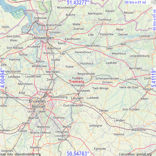
Tremelo GPS coordinates[2]
50° 59' 32.316" North, 4° 42' 29.052" East
| Map corner | latitude | longitude |
|---|---|---|
| Upper-left | 51.43277°, | 4.00494° |
| Center: | 50.99231°, | 4.70807° |
| Lower-right: | 50.54763°, | 5.41119° |
| Map W x H: | 98.4×98.4 km | = 61.1×61.1mi |
| max Lat: | 51.46791° ⇑30.3% North |
| Tremelo: | 50.99231° |
| min Lat: | ⇓69.7% South 49.53771° |
| min Long | Tremelo | max Long |
| 2.59368° | 4.70807° | 6.25749° |
| W 55.4%⇐ | ⇒44.6% E |
Elevation
Elevation of Tremelo is 10 m = 33 ft, and this is 89.5 m = 294 ft below average elevation for this country.
| Max E: |
582 m = 1909 ft | 86.5% |
| Avg. | 99.5 m = 326 ft | |
| Tremelo | 10 m = 33 ft | |
Min E: |
1 m = 3 ft | 13.5% |
See also: Belgium elevation on elevation.city.
Geographical zone
Tremelo is located in North temperate zone (between Tropic of Cancer and the Arctic Circle). Distance of this North polar circle is 1731.4 km =1075.8 mi to North.| Distance of | km | miles | from Tremelo |
|---|---|---|---|
| North Pole | 4337.2 | 2695 | to North |
| Arctic Circle | 1731.4 | 1075.8 | to North |
| Tropic Cancer | 3063.9 | 1903.8 | to South |
| Equator | 5669.8 | 3523 | to South |


Nearby cities:
15 places around Tremelo: (largest is in red/bold)
• Aarschot
9 km =5.6 mi,  93°
93°
• Begijnendijk
6.1 km =3.8 mi,  60°
60°
• Bonheiden
11.8 km =7.3 mi,  286°
286°
• Boortmeerbeek
9.5 km =5.9 mi,  261°
261°
• Haacht
5.2 km =3.2 mi,  251°
251°
• Heist-op-den-Berg
9.3 km =5.8 mi,  8°
8°
• Herent
9.7 km =6 mi,  195°
195°
• Herselt
13.9 km =8.6 mi, 61°
• Holsbeek
8.7 km =5.4 mi,  156°
156°
• Hulshout
10.8 km =6.7 mi,  32°
32°
• Kampenhout
12.3 km =7.6 mi,  243°
243°
• Keerbergen
5.3 km =3.3 mi,  282°
282°
• Leuven
12.5 km =7.8 mi,  182°
182°
• Putte
8.6 km =5.3 mi,  322°
322°
• Rotselaar
4.4 km =2.7 mi,  172°
172°
Sources, notices
• [Note1] Compared only with cities in Belgium existing in our database
• [Src1] Map data: © OpenStreetMap contributors (CC-BY-SA)
• [Src2] Other city data from geonames.org with taken over terms of usage.
• [Src3] Geographical zone / Annual Mean Temperature by Robert A. Rohde @ Wikipedia
