Boutersem geodata
Boutersem (Flanders) is a populated place; located in Belgium in Europe/Brussels (GMT+2) time zone. With population of 7,702 people, there are 376 cities with bigger population in this country. Compared to other cities in Belgium, 52.7% of cities are located further ↓South; 59.6% of cities are located further ←West and 53.4% of cities have lower elevation than Boutersem. Note1
Administrative division(s):
- Level 1: Flanders
- Level 2: Provincie Vlaams-Brabant
- Level 3: Arrondissement Leuven
- Level 4: Boutersem


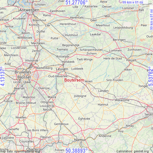
Boutersem GPS coordinates[2]
50° 50' 6.396" North, 4° 50' 4.2" East
| Map corner | latitude | longitude |
|---|---|---|
| Upper-left | 51.27706°, | 4.13137° |
| Center: | 50.83511°, | 4.8345° |
| Lower-right: | 50.38893°, | 5.53762° |
| Map W x H: | 98.8×98.7 km | = 61.4×61.3mi |
| max Lat: | 51.46791° ⇑47.3% North |
| Boutersem: | 50.83511° |
| min Lat: | ⇓52.7% South 49.53771° |
| min Long | Boutersem | max Long |
| 2.59368° | 4.8345° | 6.25749° |
| W 59.6%⇐ | ⇒40.4% E |
Elevation
Elevation of Boutersem is 58 m = 190 ft, and this is 41.5 m = 136 ft below average elevation for this country.
| Max E: |
582 m = 1909 ft | 46.6% |
| Avg. | 99.5 m = 326 ft | |
| Boutersem | 58 m = 190 ft | |
Min E: |
1 m = 3 ft | 53.4% |
See also: Belgium elevation on elevation.city.
Geographical zone
Boutersem is located in North temperate zone (between Tropic of Cancer and the Arctic Circle). Distance of this North polar circle is 1748.8 km =1086.7 mi to North.| Distance of | km | miles | from Boutersem |
|---|---|---|---|
| North Pole | 4354.7 | 2705.9 | to North |
| Arctic Circle | 1748.8 | 1086.7 | to North |
| Tropic Cancer | 3046.4 | 1892.9 | to South |
| Equator | 5652.3 | 3512.2 | to South |


Nearby cities:
15 places around Boutersem: (largest is in red/bold)
• Beauvechain
7.4 km =4.6 mi,  216°
216°
• Bekkevoort
15.1 km =9.4 mi,  38°
38°
• Bertem
14.8 km =9.2 mi,  282°
282°
• Bierbeek
5.3 km =3.3 mi,  262°
262°
• Glabbeek
9.5 km =5.9 mi,  63°
63°
• Grez-Doiceau
14.3 km =8.9 mi, 221°
• Herent
14.1 km =8.8 mi,  305°
305°
• Hoegaarden
7.7 km =4.8 mi,  149°
149°
• Holsbeek
11 km =6.8 mi,  330°
330°
• Jodoigne
12.6 km =7.8 mi,  168°
168°
• Leuven
10.6 km =6.6 mi,  297°
297°
• Lubbeek
5.3 km =3.3 mi,  3°
3°
• Oud-Heverlee
12 km =7.5 mi,  270°
270°
• Rotselaar
15.5 km =9.6 mi, 327°
• Tienen
7.9 km =4.9 mi,  112°
112°
Sources, notices
• [Note1] Compared only with cities in Belgium existing in our database
• [Src1] Map data: © OpenStreetMap contributors (CC-BY-SA)
• [Src2] Other city data from geonames.org with taken over terms of usage.
• [Src3] Geographical zone / Annual Mean Temperature by Robert A. Rohde @ Wikipedia
