Lubbeek geodata
Lubbeek (Flanders) is a populated place; located in Belgium in Europe/Brussels (GMT+2) time zone. With population of 13,574 people, there are 213 cities with bigger population in this country. Compared to other cities in Belgium, 57.9% of cities are located further ↓South; 59.9% of cities are located further ←West and 54.3% of cities have lower elevation than Lubbeek. Note1
Administrative division(s):
- Level 1: Flanders
- Level 2: Provincie Vlaams-Brabant
- Level 3: Arrondissement Leuven
- Level 4: Lubbeek


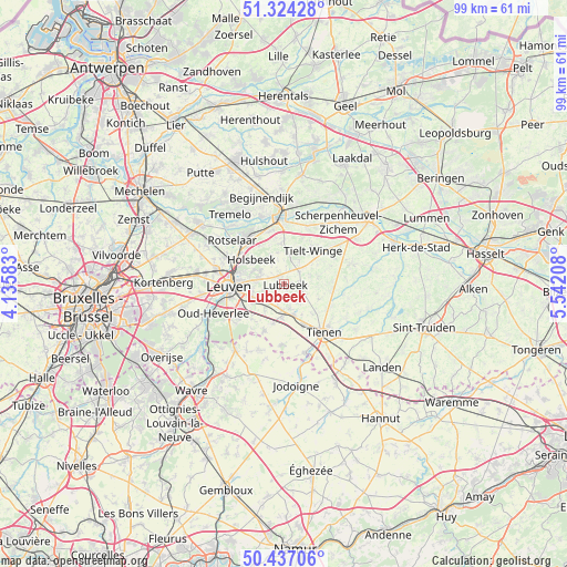
Lubbeek GPS coordinates[2]
50° 52' 58.008" North, 4° 50' 20.256" East
| Map corner | latitude | longitude |
|---|---|---|
| Upper-left | 51.32428°, | 4.13583° |
| Center: | 50.88278°, | 4.83896° |
| Lower-right: | 50.43706°, | 5.54208° |
| Map W x H: | 98.6×98.6 km | = 61.3×61.3mi |
| max Lat: | 51.46791° ⇑42.1% North |
| Lubbeek: | 50.88278° |
| min Lat: | ⇓57.9% South 49.53771° |
| min Long | Lubbeek | max Long |
| 2.59368° | 4.83896° | 6.25749° |
| W 59.9%⇐ | ⇒40.1% E |
Elevation
Elevation of Lubbeek is 59 m = 194 ft, and this is 40.5 m = 133 ft below average elevation for this country.
| Max E: |
582 m = 1909 ft | 45.7% |
| Avg. | 99.5 m = 326 ft | |
| Lubbeek | 59 m = 194 ft | |
Min E: |
1 m = 3 ft | 54.3% |
See also: Belgium elevation on elevation.city.
Geographical zone
Lubbeek is located in North temperate zone (between Tropic of Cancer and the Arctic Circle). Distance of this North polar circle is 1743.5 km =1083.4 mi to North.| Distance of | km | miles | from Lubbeek |
|---|---|---|---|
| North Pole | 4349.4 | 2702.6 | to North |
| Arctic Circle | 1743.5 | 1083.4 | to North |
| Tropic Cancer | 3051.7 | 1896.2 | to South |
| Equator | 5657.6 | 3515.5 | to South |


Nearby cities:
15 places around Lubbeek: (largest is in red/bold)
• Aarschot
11.6 km =7.2 mi,  359°
359°
• Beauvechain
12.2 km =7.6 mi,  202°
202°
• Bekkevoort
11.2 km =7 mi,  54°
54°
• Bertem
14.9 km =9.3 mi,  261°
261°
• Bierbeek
8.2 km =5.1 mi,  222°
222°
• Boutersem
5.3 km =3.3 mi,  183°
183°
• Glabbeek
8.3 km =5.2 mi,  97°
97°
• Herent
12.2 km =7.6 mi,  283°
283°
• Hoegaarden
12.4 km =7.7 mi,  163°
163°
• Holsbeek
7.1 km =4.4 mi,  306°
306°
• Leuven
9.7 km =6 mi,  267°
267°
• Oud-Heverlee
13.4 km =8.3 mi,  246°
246°
• Rotselaar
11.6 km =7.2 mi, 312°
• Tienen
10.9 km =6.8 mi,  140°
140°
• Tremelo
15.2 km =9.4 mi,  323°
323°
Sources, notices
• [Note1] Compared only with cities in Belgium existing in our database
• [Src1] Map data: © OpenStreetMap contributors (CC-BY-SA)
• [Src2] Other city data from geonames.org with taken over terms of usage.
• [Src3] Geographical zone / Annual Mean Temperature by Robert A. Rohde @ Wikipedia
