Tienen geodata
Tienen (Flanders) is a populated place; located in Belgium in Europe/Brussels (GMT+2) time zone. With population of 31,743 people, there are 52 cities with bigger population in this country. Compared to other cities in Belgium, 50.5% of cities are located further ↓South; 63.4% of cities are located further ←West and 52% of cities have higher elevation than Tienen. Note1
Administrative division(s):
- Level 1: Flanders
- Level 2: Provincie Vlaams-Brabant
- Level 3: Arrondissement Leuven
- Level 4: Tienen


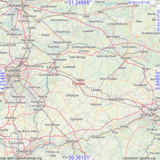
Tienen GPS coordinates[2]
50° 48' 26.82" North, 4° 56' 16.08" East
| Map corner | latitude | longitude |
|---|---|---|
| Upper-left | 51.24966°, | 4.23468° |
| Center: | 50.80745°, | 4.9378° |
| Lower-right: | 50.36101°, | 5.64093° |
| Map W x H: | 98.8×98.8 km | = 61.4×61.4mi |
| max Lat: | 51.46791° ⇑49.5% North |
| Tienen: | 50.80745° |
| min Lat: | ⇓50.5% South 49.53771° |
| min Long | Tienen | max Long |
| 2.59368° | 4.9378° | 6.25749° |
| W 63.4%⇐ | ⇒36.6% E |
Elevation
Elevation of Tienen is 46 m = 151 ft, and this is 53.5 m = 176 ft below average elevation for this country.
| Max E: |
582 m = 1909 ft | 52% |
| Avg. | 99.5 m = 326 ft | |
| Tienen | 46 m = 151 ft | |
Min E: |
1 m = 3 ft | 48% |
See also: Belgium elevation on elevation.city.
Geographical zone
Tienen is located in North temperate zone (between Tropic of Cancer and the Arctic Circle). Distance of this North polar circle is 1751.9 km =1088.6 mi to North.| Distance of | km | miles | from Tienen |
|---|---|---|---|
| North Pole | 4357.8 | 2707.8 | to North |
| Arctic Circle | 1751.9 | 1088.6 | to North |
| Tropic Cancer | 3043.3 | 1891 | to South |
| Equator | 5649.3 | 3510.3 | to South |


Nearby cities:
15 places around Tienen: (largest is in red/bold)
• Beauvechain
12 km =7.5 mi,  256°
256°
• Bekkevoort
15 km =9.3 mi,  8°
8°
• Bierbeek
12.7 km =7.9 mi,  280°
280°
• Boutersem
7.9 km =4.9 mi,  292°
292°
• Geetbets
15.6 km =9.7 mi,  51°
51°
• Gingelom
15.3 km =9.5 mi,  115°
115°
• Glabbeek
7.4 km =4.6 mi, 10°
• Hoegaarden
4.9 km =3 mi,  223°
223°
• Incourt
16.2 km =10.1 mi, 217°
• Jodoigne
10.5 km =6.5 mi,  207°
207°
• Kortenaken
14.1 km =8.8 mi,  37°
37°
• Landen
11.8 km =7.3 mi, 120°
• Lincent
12.7 km =7.9 mi,  146°
146°
• Lubbeek
10.9 km =6.8 mi,  320°
320°
• Zoutleeuw
12 km =7.5 mi,  76°
76°
Sources, notices
• [Note1] Compared only with cities in Belgium existing in our database
• [Src1] Map data: © OpenStreetMap contributors (CC-BY-SA)
• [Src2] Other city data from geonames.org with taken over terms of usage.
• [Src3] Geographical zone / Annual Mean Temperature by Robert A. Rohde @ Wikipedia
