Halen geodata
Halen (Flanders) is a populated place; located in Belgium in Europe/Brussels (GMT+2) time zone. With population of 8,548 people, there are 347 cities with bigger population in this country. Compared to other cities in Belgium, 65.5% of cities are located further ↓South; 70.2% of cities are located further ←West and 67.3% of cities have higher elevation than Halen. Note1
Administrative division(s):
- Level 1: Flanders
- Level 2: Provincie Limburg
- Level 3: Arrondissement Hasselt
- Level 4: Halen


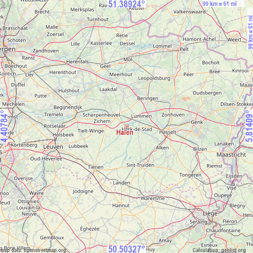
Halen GPS coordinates[2]
50° 56' 54.132" North, 5° 6' 39.456" East
| Map corner | latitude | longitude |
|---|---|---|
| Upper-left | 51.38924°, | 4.40784° |
| Center: | 50.94837°, | 5.11096° |
| Lower-right: | 50.50327°, | 5.81409° |
| Map W x H: | 98.5×98.5 km | = 61.2×61.2mi |
| max Lat: | 51.46791° ⇑34.5% North |
| Halen: | 50.94837° |
| min Lat: | ⇓65.5% South 49.53771° |
| min Long | Halen | max Long |
| 2.59368° | 5.11096° | 6.25749° |
| W 70.2%⇐ | ⇒29.8% E |
Elevation
Elevation of Halen is 24 m = 79 ft, and this is 75.5 m = 248 ft below average elevation for this country.
| Max E: |
582 m = 1909 ft | 67.3% |
| Avg. | 99.5 m = 326 ft | |
| Halen | 24 m = 79 ft | |
Min E: |
1 m = 3 ft | 32.7% |
See also: Belgium elevation on elevation.city.
Geographical zone
Halen is located in North temperate zone (between Tropic of Cancer and the Arctic Circle). Distance of this North polar circle is 1736.2 km =1078.8 mi to North.| Distance of | km | miles | from Halen |
|---|---|---|---|
| North Pole | 4342.1 | 2698.1 | to North |
| Arctic Circle | 1736.2 | 1078.8 | to North |
| Tropic Cancer | 3059 | 1900.8 | to South |
| Equator | 5664.9 | 3520 | to South |


Nearby cities:
15 places around Halen: (largest is in red/bold)
• Bekkevoort
10 km =6.2 mi,  265°
265°
• Beringen
13.8 km =8.6 mi,  35°
35°
• Diest
6.2 km =3.9 mi,  317°
317°
• Geetbets
6 km =3.7 mi,  179°
179°
• Glabbeek
13.7 km =8.5 mi,  232°
232°
• Herk-de-Stad
4 km =2.5 mi,  103°
103°
• Heusden
15.4 km =9.6 mi,  50°
50°
• Kortenaken
5.7 km =3.5 mi,  219°
219°
• Lummen
7.1 km =4.4 mi, 52°
• Nieuwerkerken
11.1 km =6.9 mi,  148°
148°
• Scherpenheuvel-Zichem
11.8 km =7.3 mi,  305°
305°
• Sint-Joris
14.2 km =8.8 mi,  127°
127°
• Terkoest
12.9 km =8 mi,  115°
115°
• Tessenderlo
13.1 km =8.1 mi,  353°
353°
• Zoutleeuw
12.8 km =8 mi, 182°
Sources, notices
• [Note1] Compared only with cities in Belgium existing in our database
• [Src1] Map data: © OpenStreetMap contributors (CC-BY-SA)
• [Src2] Other city data from geonames.org with taken over terms of usage.
• [Src3] Geographical zone / Annual Mean Temperature by Robert A. Rohde @ Wikipedia
