Kortenaken geodata
Kortenaken (Flanders) is a populated place; located in Belgium in Europe/Brussels (GMT+2) time zone. With population of 7,374 people, there are 389 cities with bigger population in this country. Compared to other cities in Belgium, 61.6% of cities are located further ↓South; 67.7% of cities are located further ←West and 58.7% of cities have higher elevation than Kortenaken. Note1
Administrative division(s):
- Level 1: Flanders
- Level 2: Provincie Vlaams-Brabant
- Level 3: Arrondissement Leuven
- Level 4: Kortenaken


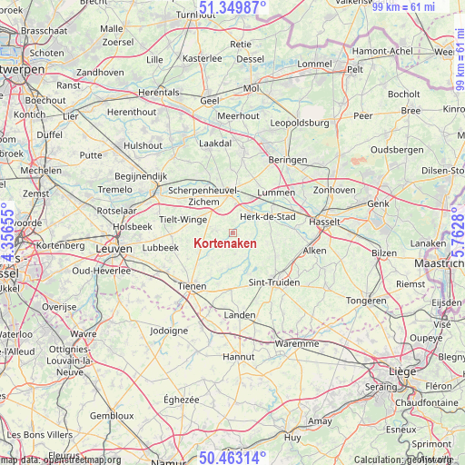
Kortenaken GPS coordinates[2]
50° 54' 31.032" North, 5° 3' 34.848" East
| Map corner | latitude | longitude |
|---|---|---|
| Upper-left | 51.34987°, | 4.35655° |
| Center: | 50.90862°, | 5.05968° |
| Lower-right: | 50.46314°, | 5.7628° |
| Map W x H: | 98.6×98.6 km | = 61.3×61.3mi |
| max Lat: | 51.46791° ⇑38.4% North |
| Kortenaken: | 50.90862° |
| min Lat: | ⇓61.6% South 49.53771° |
| min Long | Kortenaken | max Long |
| 2.59368° | 5.05968° | 6.25749° |
| W 67.7%⇐ | ⇒32.3% E |
Elevation
Elevation of Kortenaken is 35 m = 115 ft, and this is 64.5 m = 212 ft below average elevation for this country.
| Max E: |
582 m = 1909 ft | 58.7% |
| Avg. | 99.5 m = 326 ft | |
| Kortenaken | 35 m = 115 ft | |
Min E: |
1 m = 3 ft | 41.3% |
See also: Belgium elevation on elevation.city.
Geographical zone
Kortenaken is located in North temperate zone (between Tropic of Cancer and the Arctic Circle). Distance of this North polar circle is 1740.7 km =1081.6 mi to North.| Distance of | km | miles | from Kortenaken |
|---|---|---|---|
| North Pole | 4346.6 | 2700.9 | to North |
| Arctic Circle | 1740.7 | 1081.6 | to North |
| Tropic Cancer | 3054.6 | 1898 | to South |
| Equator | 5660.5 | 3517.3 | to South |


Nearby cities:
15 places around Kortenaken: (largest is in red/bold)
• Bekkevoort
7.3 km =4.5 mi,  299°
299°
• Diest
9 km =5.6 mi,  355°
355°
• Geetbets
4 km =2.5 mi,  113°
113°
• Glabbeek
8.3 km =5.2 mi,  241°
241°
• Halen
5.7 km =3.5 mi,  39°
39°
• Herk-de-Stad
8.3 km =5.2 mi,  64°
64°
• Lubbeek
15.7 km =9.8 mi,  259°
259°
• Lummen
12.7 km =7.9 mi,  46°
46°
• Nieuwerkerken
10.7 km =6.6 mi,  117°
117°
• Scherpenheuvel-Zichem
12.8 km =8 mi,  332°
332°
• Sint-Joris
15.5 km =9.6 mi, 105°
• Sint-Truiden
13.5 km =8.4 mi,  138°
138°
• Terkoest
15.2 km =9.4 mi,  94°
94°
• Tienen
14.1 km =8.8 mi,  217°
217°
• Zoutleeuw
8.9 km =5.5 mi,  159°
159°
Sources, notices
• [Note1] Compared only with cities in Belgium existing in our database
• [Src1] Map data: © OpenStreetMap contributors (CC-BY-SA)
• [Src2] Other city data from geonames.org with taken over terms of usage.
• [Src3] Geographical zone / Annual Mean Temperature by Robert A. Rohde @ Wikipedia
