Scherpenheuvel-Zichem geodata
Scherpenheuvel-Zichem (Flanders) is a seat of a fourth-order administrative division; located in Belgium in Europe/Brussels (GMT+2) time zone. In our database, there are 548 cities with bigger population. Compared to other cities in Belgium, 72% of cities are located further ↓South; 64.8% of cities are located further ←West and 79.4% of cities have higher elevation than Scherpenheuvel-Zichem. Note1
Administrative division(s):
- Level 1: Flanders
- Level 2: Provincie Vlaams-Brabant
- Level 3: Arrondissement Leuven
- Level 4: Scherpenheuvel-Zichem
Current local time in Scherpenheuvel-Zichem:
09:42 AM, ThursdayDifference from your time zone: hours


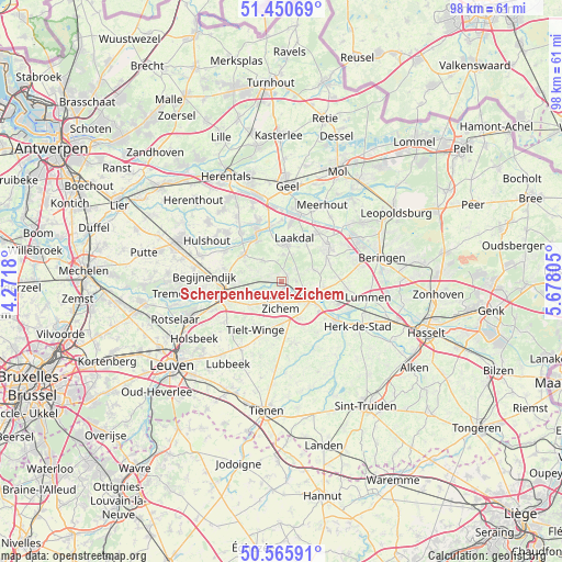
Scherpenheuvel-Zichem GPS coordinates[2]
51° 0' 37.476" North, 4° 58' 29.712" East
| Map corner | latitude | longitude |
|---|---|---|
| Upper-left | 51.45069°, | 4.2718° |
| Center: | 51.01041°, | 4.97492° |
| Lower-right: | 50.56591°, | 5.67805° |
| Map W x H: | 98.4×98.4 km | = 61.1×61.1mi |
| max Lat: | 51.46791° ⇑28% North |
| Scherpenheuvel-Zichem: | 51.01041° |
| min Lat: | ⇓72% South 49.53771° |
| min Long | Scherpenheuvel- | max Long |
| 2.59368° | 4.97492° | 6.25749° |
| W 64.8%⇐ | ⇒35.2% E |
Elevation
Elevation of Scherpenheuvel-Zichem is 14 m = 46 ft, and this is 85.5 m = 281 ft below average elevation for this country.
| Max E: |
582 m = 1909 ft | 79.4% |
| Avg. | 99.5 m = 326 ft | |
| Scherpenheuvel-Zichem | 14 m = 46 ft | |
Min E: |
1 m = 3 ft | 20.6% |
See also: Belgium elevation on elevation.city.
Geographical zone
Scherpenheuvel-Zichem is located in North temperate zone (between Tropic of Cancer and the Arctic Circle). Distance of this North polar circle is 1729.3 km =1074.5 mi to North.| Distance of | km | miles | from Scherpenheuvel-Zichem |
|---|---|---|---|
| North Pole | 4335.2 | 2693.8 | to North |
| Arctic Circle | 1729.3 | 1074.5 | to North |
| Tropic Cancer | 3065.9 | 1905.1 | to South |
| Equator | 5671.8 | 3524.3 | to South |


Nearby cities:
15 places around Scherpenheuvel-Zichem: (largest is in red/bold)
• Aarschot
10 km =6.2 mi,  255°
255°
• Begijnendijk
13.4 km =8.3 mi,  274°
274°
• Bekkevoort
7.8 km =4.8 mi,  183°
183°
• Diest
5.8 km =3.6 mi,  113°
113°
• Glabbeek
15.4 km =9.6 mi, 184°
• Halen
11.8 km =7.3 mi,  125°
125°
• Herk-de-Stad
15.5 km =9.6 mi,  120°
120°
• Herselt
7.9 km =4.9 mi,  305°
305°
• Hulshout
14.7 km =9.1 mi,  298°
298°
• Kortenaken
12.8 km =8 mi,  152°
152°
• Laakdal
8.1 km =5 mi,  15°
15°
• Lummen
15.3 km =9.5 mi,  99°
99°
• Meerhout
15.3 km =9.5 mi,  28°
28°
• Tessenderlo
10 km =6.2 mi,  52°
52°
• Westerlo
9.8 km =6.1 mi,  334°
334°
Sources, notices
• [Note1] Compared only with cities in Belgium existing in our database
• [Src1] Map data: © OpenStreetMap contributors (CC-BY-SA)
• [Src2] Other city data from geonames.org with taken over terms of usage.
• [Src3] Geographical zone / Annual Mean Temperature by Robert A. Rohde @ Wikipedia
