Geetbets geodata
Geetbets (Flanders) is a populated place; located in Belgium in Europe/Brussels (GMT+2) time zone. With population of 5,813 people, there are 427 cities with bigger population in this country. Compared to other cities in Belgium, 59.7% of cities are located further ↓South; 70.4% of cities are located further ←West and 62.3% of cities have higher elevation than Geetbets. Note1
Administrative division(s):
- Level 1: Flanders
- Level 2: Provincie Vlaams-Brabant
- Level 3: Arrondissement Leuven
- Level 4: Geetbets


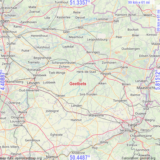
Geetbets GPS coordinates[2]
50° 53' 39.516" North, 5° 6' 43.164" East
| Map corner | latitude | longitude |
|---|---|---|
| Upper-left | 51.3357°, | 4.40887° |
| Center: | 50.89431°, | 5.11199° |
| Lower-right: | 50.4487°, | 5.81512° |
| Map W x H: | 98.6×98.6 km | = 61.3×61.3mi |
| max Lat: | 51.46791° ⇑40.3% North |
| Geetbets: | 50.89431° |
| min Lat: | ⇓59.7% South 49.53771° |
| min Long | Geetbets | max Long |
| 2.59368° | 5.11199° | 6.25749° |
| W 70.4%⇐ | ⇒29.6% E |
Elevation
Elevation of Geetbets is 30 m = 98 ft, and this is 69.5 m = 228 ft below average elevation for this country.
| Max E: |
582 m = 1909 ft | 62.3% |
| Avg. | 99.5 m = 326 ft | |
| Geetbets | 30 m = 98 ft | |
Min E: |
1 m = 3 ft | 37.7% |
See also: Belgium elevation on elevation.city.
Geographical zone
Geetbets is located in North temperate zone (between Tropic of Cancer and the Arctic Circle). Distance of this North polar circle is 1742.3 km =1082.6 mi to North.| Distance of | km | miles | from Geetbets |
|---|---|---|---|
| North Pole | 4348.1 | 2701.8 | to North |
| Arctic Circle | 1742.3 | 1082.6 | to North |
| Tropic Cancer | 3053 | 1897 | to South |
| Equator | 5658.9 | 3516.3 | to South |


Nearby cities:
15 places around Geetbets: (largest is in red/bold)
• Alken
13.7 km =8.5 mi,  98°
98°
• Bekkevoort
11.3 km =7 mi,  297°
297°
• Diest
11.4 km =7.1 mi,  337°
337°
• Glabbeek
11.2 km =7 mi,  257°
257°
• Halen
6 km =3.7 mi,  359°
359°
• Herk-de-Stad
6.4 km =4 mi,  36°
36°
• Kortenaken
4 km =2.5 mi,  293°
293°
• Landen
15.9 km =9.9 mi,  187°
187°
• Lummen
11.8 km =7.3 mi,  28°
28°
• Nieuwerkerken
6.7 km =4.2 mi,  120°
120°
• Sint-Joris
11.5 km =7.1 mi, 102°
• Sint-Truiden
10.1 km =6.3 mi,  148°
148°
• Terkoest
11.5 km =7.1 mi,  87°
87°
• Tienen
15.6 km =9.7 mi,  231°
231°
• Zoutleeuw
6.8 km =4.2 mi,  184°
184°
Sources, notices
• [Note1] Compared only with cities in Belgium existing in our database
• [Src1] Map data: © OpenStreetMap contributors (CC-BY-SA)
• [Src2] Other city data from geonames.org with taken over terms of usage.
• [Src3] Geographical zone / Annual Mean Temperature by Robert A. Rohde @ Wikipedia
