Tessenderlo geodata
Tessenderlo (Flanders) is a populated place; located in Belgium in Europe/Brussels (GMT+2) time zone. With population of 16,574 people, there are 166 cities with bigger population in this country. Compared to other cities in Belgium, 77.1% of cities are located further ↓South; 69.3% of cities are located further ←West and 64.3% of cities have higher elevation than Tessenderlo. Note1
Administrative division(s):
- Level 1: Flanders
- Level 2: Provincie Limburg
- Level 3: Arrondissement Hasselt
- Level 4: Tessenderlo


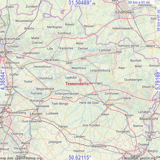
Tessenderlo GPS coordinates[2]
51° 3' 54.468" North, 5° 5' 18.816" East
| Map corner | latitude | longitude |
|---|---|---|
| Upper-left | 51.50489°, | 4.38544° |
| Center: | 51.06513°, | 5.08856° |
| Lower-right: | 50.62115°, | 5.79169° |
| Map W x H: | 98.3×98.3 km | = 61.1×61.1mi |
| max Lat: | 51.46791° ⇑22.9% North |
| Tessenderlo: | 51.06513° |
| min Lat: | ⇓77.1% South 49.53771° |
| min Long | Tessenderlo | max Long |
| 2.59368° | 5.08856° | 6.25749° |
| W 69.3%⇐ | ⇒30.7% E |
Elevation
Elevation of Tessenderlo is 27 m = 89 ft, and this is 72.5 m = 238 ft below average elevation for this country.
| Max E: |
582 m = 1909 ft | 64.3% |
| Avg. | 99.5 m = 326 ft | |
| Tessenderlo | 27 m = 89 ft | |
Min E: |
1 m = 3 ft | 35.7% |
See also: Belgium elevation on elevation.city.
Geographical zone
Tessenderlo is located in North temperate zone (between Tropic of Cancer and the Arctic Circle). Distance of this North polar circle is 1723.3 km =1070.8 mi to North.| Distance of | km | miles | from Tessenderlo |
|---|---|---|---|
| North Pole | 4329.2 | 2690 | to North |
| Arctic Circle | 1723.3 | 1070.8 | to North |
| Tropic Cancer | 3072 | 1908.9 | to South |
| Equator | 5677.9 | 3528.1 | to South |


Nearby cities:
15 places around Tessenderlo: (largest is in red/bold)
• Balen
12.8 km =8 mi,  26°
26°
• Beringen
9.8 km =6.1 mi,  100°
100°
• Diest
8.8 km =5.5 mi,  197°
197°
• Geel
13.1 km =8.1 mi,  328°
328°
• Halen
13.1 km =8.1 mi,  173°
173°
• Herk-de-Stad
14.9 km =9.3 mi,  158°
158°
• Herselt
14.5 km =9 mi,  264°
264°
• Heusden
13.8 km =8.6 mi, 103°
• Laakdal
6.1 km =3.8 mi,  286°
286°
• Leopoldsburg
12.6 km =7.8 mi,  63°
63°
• Lummen
11.2 km =7 mi,  140°
140°
• Meerhout
7.5 km =4.7 mi,  354°
354°
• Mol
14.2 km =8.8 mi,  7°
7°
• Scherpenheuvel-Zichem
10 km =6.2 mi,  232°
232°
• Westerlo
12.4 km =7.7 mi,  283°
283°
Sources, notices
• [Note1] Compared only with cities in Belgium existing in our database
• [Src1] Map data: © OpenStreetMap contributors (CC-BY-SA)
• [Src2] Other city data from geonames.org with taken over terms of usage.
• [Src3] Geographical zone / Annual Mean Temperature by Robert A. Rohde @ Wikipedia
