Diest geodata
Diest (Flanders) is a populated place; located in Belgium in Europe/Brussels (GMT+2) time zone. With population of 22,516 people, there are 97 cities with bigger population in this country. Compared to other cities in Belgium, 69.3% of cities are located further ↓South; 67.5% of cities are located further ←West and 70% of cities have higher elevation than Diest. Note1
Administrative division(s):
- Level 1: Flanders
- Level 2: Provincie Vlaams-Brabant
- Level 3: Arrondissement Leuven
- Level 4: Diest


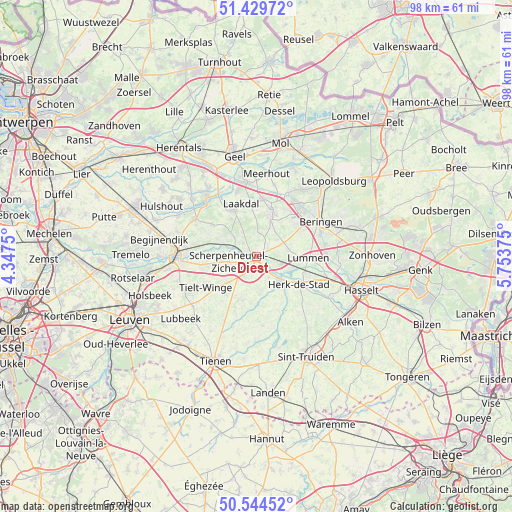
Diest GPS coordinates[2]
50° 59' 21.228" North, 5° 3' 2.232" East
| Map corner | latitude | longitude |
|---|---|---|
| Upper-left | 51.42972°, | 4.3475° |
| Center: | 50.98923°, | 5.05062° |
| Lower-right: | 50.54452°, | 5.75375° |
| Map W x H: | 98.4×98.4 km | = 61.1×61.1mi |
| max Lat: | 51.46791° ⇑30.7% North |
| Diest: | 50.98923° |
| min Lat: | ⇓69.3% South 49.53771° |
| min Long | Diest | max Long |
| 2.59368° | 5.05062° | 6.25749° |
| W 67.5%⇐ | ⇒32.5% E |
Elevation
Elevation of Diest is 22 m = 72 ft, and this is 77.5 m = 254 ft below average elevation for this country.
| Max E: |
582 m = 1909 ft | 70% |
| Avg. | 99.5 m = 326 ft | |
| Diest | 22 m = 72 ft | |
Min E: |
1 m = 3 ft | 30% |
See also: Belgium elevation on elevation.city.
Geographical zone
Diest is located in North temperate zone (between Tropic of Cancer and the Arctic Circle). Distance of this North polar circle is 1731.7 km =1076 mi to North.| Distance of | km | miles | from Diest |
|---|---|---|---|
| North Pole | 4337.6 | 2695.3 | to North |
| Arctic Circle | 1731.7 | 1076 | to North |
| Tropic Cancer | 3063.6 | 1903.6 | to South |
| Equator | 5669.5 | 3522.9 | to South |


Nearby cities:
15 places around Diest: (largest is in red/bold)
• Aarschot
15 km =9.3 mi,  269°
269°
• Bekkevoort
7.9 km =4.9 mi,  226°
226°
• Beringen
14 km =8.7 mi,  61°
61°
• Geetbets
11.4 km =7.1 mi,  157°
157°
• Glabbeek
14.6 km =9.1 mi,  207°
207°
• Halen
6.2 km =3.9 mi,  137°
137°
• Herk-de-Stad
9.8 km =6.1 mi,  123°
123°
• Herselt
13.7 km =8.5 mi,  300°
300°
• Kortenaken
9 km =5.6 mi,  175°
175°
• Laakdal
10.6 km =6.6 mi,  342°
342°
• Lummen
9.8 km =6.1 mi,  90°
90°
• Meerhout
16 km =9.9 mi,  6°
6°
• Scherpenheuvel-Zichem
5.8 km =3.6 mi,  293°
293°
• Tessenderlo
8.8 km =5.5 mi,  17°
17°
• Westerlo
14.7 km =9.1 mi,  319°
319°
Sources, notices
• [Note1] Compared only with cities in Belgium existing in our database
• [Src1] Map data: © OpenStreetMap contributors (CC-BY-SA)
• [Src2] Other city data from geonames.org with taken over terms of usage.
• [Src3] Geographical zone / Annual Mean Temperature by Robert A. Rohde @ Wikipedia
