Zorgo geodata
Zorgo (Plateau-Central) is a seat of a second-order administrative division; located in Burkina Faso in Africa/Ouagadougou (GMT+0) time zone. With population of 23,892 people, there are 20 cities with bigger population in this country. Compared to other cities in Burkina Faso, 62% of cities are located further ↑North; 77.2% of cities are located further ←West and 64.6% of cities have lower elevation than Zorgo. Note1


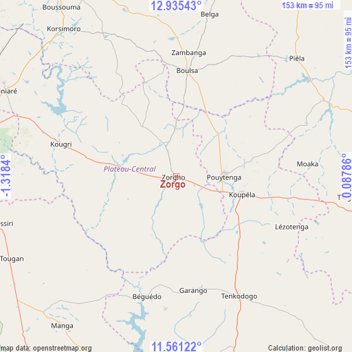
Zorgo GPS coordinates[2]
12° 14' 57.192" North, 0° 36' 54.972" West
| Map corner | latitude | longitude |
|---|---|---|
| Upper-left | 12.93543°, | -1.3184° |
| Center: | 12.24922°, | -0.61527° |
| Lower-right: | 11.56122°, | 0.08786° |
| Map W x H: | 152.8×152.8 km | = 94.9×94.9mi |
| max Lat: | 14.96549° ⇑62% North |
| Zorgo: | 12.24922° |
| min Lat: | ⇓38% South 9.88333° |
| min Long | Zorgo | max Long |
| -5.16667° | -0.61527° | 1.78838° |
| W 77.2%⇐ | ⇒22.8% E |
Elevation
Elevation of Zorgo is 312 m = 1024 ft, and this is 9 m = 30 ft above average elevation for this country.
| Max E: |
423 m = 1388 ft | 35.4% |
| Zorgo | 312 m 1024 ft | |
| Avg. | 303 m = 994 ft | |
Min E: |
222 m = 728 ft | 64.6% |
See also: Burkina Faso elevation on elevation.city.
Geographical zone
Zorgo is located in North Torrid zone (between Equator and Tropic of Cancer). Distance of this Northern Tropic circle is 1243.9 km =772.9 mi to North.| Distance of | km | miles | from Zorgo |
|---|---|---|---|
| North Pole | 8645.1 | 5371.8 | to North |
| Arctic Circle | 6039.2 | 3752.6 | to North |
| Tropic Cancer | 1243.9 | 772.9 | to North |
| Equator | 1362 | 846.3 | to South |


Nearby cities:
15 places around Zorgo: (largest is in red/bold)
• Absouya
64.5 km =40.1 mi,  312°
312°
• Bilanga
72.2 km =44.9 mi,  62°
62°
• Boulsa
46.6 km =29 mi,  5°
5°
• Gaongo
65.6 km =40.8 mi,  245°
245°
• Garango
50.4 km =31.3 mi,  171°
171°
• Kombissiri
80.9 km =50.3 mi,  255°
255°
• Korsimoro
80.7 km =50.1 mi,  322°
322°
• Koubri
86.2 km =53.6 mi,  266°
266°
• Koupéla
29.8 km =18.5 mi,  105°
105°
• Loumbila
87.6 km =54.4 mi,  289°
289°
• Manga
82 km =51 mi,  217°
217°
• Nagréongo
68.6 km =42.6 mi, 291°
• Saaba
87.9 km =54.6 mi,  278°
278°
• Tenkodogo
58.6 km =36.4 mi,  152°
152°
• Ziniaré
82.8 km =51.4 mi,  296°
296°
Sources, notices
• [Note1] Compared only with cities in Burkina Faso existing in our database
• [Src1] Map data: © OpenStreetMap contributors (CC-BY-SA)
• [Src2] Other city data from geonames.org with taken over terms of usage.
• [Src3] Geographical zone / Annual Mean Temperature by Robert A. Rohde @ Wikipedia
