Bilanga geodata
Bilanga (Est) is a seat of a third-order administrative division; located in Burkina Faso in Africa/Ouagadougou (GMT+0) time zone. In our database, there are 49 cities with bigger population. Compared to other cities in Burkina Faso, 54.4% of cities are located further ↓South; 91.1% of cities are located further ←West and 81% of cities have higher elevation than Bilanga. Note1


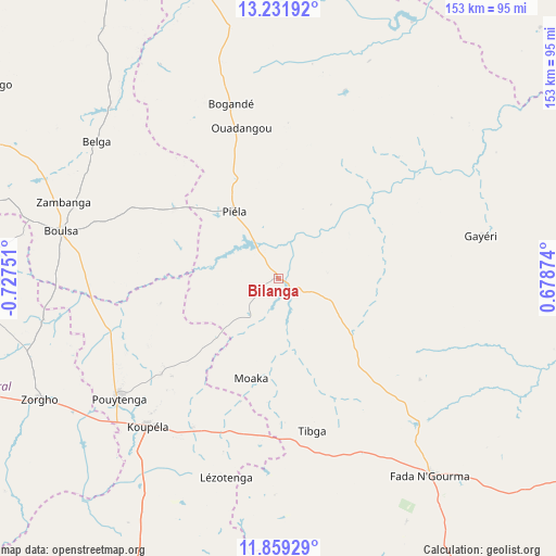
Bilanga GPS coordinates[2]
12° 32' 47.472" North, 0° 1' 27.768" West
| Map corner | latitude | longitude |
|---|---|---|
| Upper-left | 13.23192°, | -0.72751° |
| Center: | 12.54652°, | -0.02438° |
| Lower-right: | 11.85929°, | 0.67874° |
| Map W x H: | 152.6×152.6 km | = 94.8×94.8mi |
| max Lat: | 14.96549° ⇑45.6% North |
| Bilanga: | 12.54652° |
| min Lat: | ⇓54.4% South 9.88333° |
| min Long | Bilanga | max Long |
| -5.16667° | -0.02438° | 1.78838° |
| W 91.1%⇐ | ⇒8.9% E |
Elevation
Elevation of Bilanga is 280 m = 919 ft, and this is 23 m = 75 ft below average elevation for this country.
| Max E: |
423 m = 1388 ft | 81% |
| Avg. | 303 m = 994 ft | |
| Bilanga | 280 m = 919 ft | |
Min E: |
222 m = 728 ft | 19% |
See also: Burkina Faso elevation on elevation.city.
Geographical zone
Bilanga is located in North Torrid zone (between Equator and Tropic of Cancer). Distance of this Northern Tropic circle is 1210.9 km =752.4 mi to North.| Distance of | km | miles | from Bilanga |
|---|---|---|---|
| North Pole | 8612 | 5351.2 | to North |
| Arctic Circle | 6006.1 | 3732 | to North |
| Tropic Cancer | 1210.9 | 752.4 | to North |
| Equator | 1395 | 866.8 | to South |


Nearby cities:
15 places around Bilanga: (largest is in red/bold)
• Absouya
112.2 km =69.7 mi,  275°
275°
• Bogandé
49 km =30.4 mi,  343°
343°
• Boulsa
61.2 km =38 mi, 282°
• Boussouma
121.6 km =75.6 mi,  289°
289°
• Fada N'gourma
68.1 km =42.3 mi,  142°
142°
• Garango
100.8 km =62.6 mi,  214°
214°
• Gayéri
57.3 km =35.6 mi,  78°
78°
• Korsimoro
117.3 km =72.9 mi, 285°
• Koupéla
54.1 km =33.6 mi,  220°
220°
• Mani
81.7 km =50.8 mi,  345°
345°
• Nagréongo
128 km =79.5 mi,  266°
266°
• Ouargaye
116.5 km =72.4 mi,  175°
175°
• Sebba
115.8 km =72 mi,  31°
31°
• Tenkodogo
93.1 km =57.8 mi,  203°
203°
• Zorgo
72.2 km =44.9 mi,  242°
242°
Sources, notices
• [Note1] Compared only with cities in Burkina Faso existing in our database
• [Src1] Map data: © OpenStreetMap contributors (CC-BY-SA)
• [Src2] Other city data from geonames.org with taken over terms of usage.
• [Src3] Geographical zone / Annual Mean Temperature by Robert A. Rohde @ Wikipedia
