Garango geodata
Garango (Centre-Est) is a populated place; located in Burkina Faso in Africa/Ouagadougou (GMT+0) time zone. With population of 29,076 people, there are 14 cities with bigger population in this country. Compared to other cities in Burkina Faso, 81% of cities are located further ↑North; 79.7% of cities are located further ←West and 50.6% of cities have lower elevation than Garango. Note1


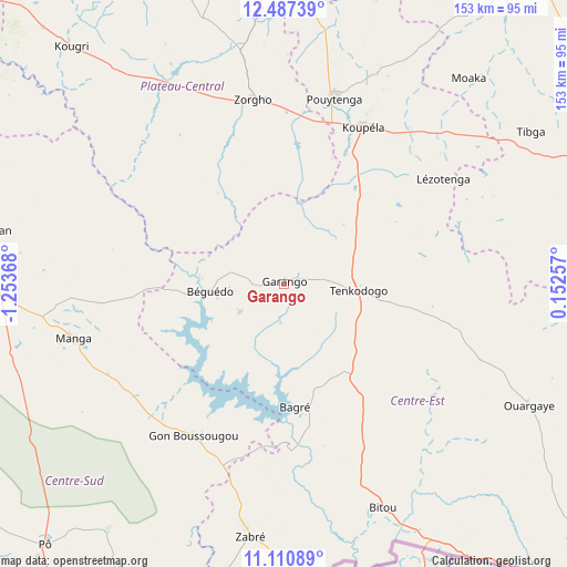
Garango GPS coordinates[2]
11° 48' 0" North, 0° 33' 2.016" West
| Map corner | latitude | longitude |
|---|---|---|
| Upper-left | 12.48739°, | -1.25368° |
| Center: | 11.8°, | -0.55056° |
| Lower-right: | 11.11089°, | 0.15257° |
| Map W x H: | 153.1×153.1 km | = 95.1×95.1mi |
| max Lat: | 14.96549° ⇑81% North |
| Garango: | 11.8° |
| min Lat: | ⇓19% South 9.88333° |
| min Long | Garango | max Long |
| -5.16667° | -0.55056° | 1.78838° |
| W 79.7%⇐ | ⇒20.3% E |
Elevation
Elevation of Garango is 304 m = 997 ft, and this is 1 m = 3 ft above average elevation for this country.
| Max E: |
423 m = 1388 ft | 49.4% |
| Garango | 304 m 997 ft | |
| Avg. | 303 m = 994 ft | |
Min E: |
222 m = 728 ft | 50.6% |
See also: Burkina Faso elevation on elevation.city.
Geographical zone
Garango is located in North Torrid zone (between Equator and Tropic of Cancer). Distance of this Northern Tropic circle is 1293.9 km =804 mi to North.| Distance of | km | miles | from Garango |
|---|---|---|---|
| North Pole | 8695 | 5402.8 | to North |
| Arctic Circle | 6089.1 | 3783.6 | to North |
| Tropic Cancer | 1293.9 | 804 | to North |
| Equator | 1312 | 815.2 | to South |


Nearby cities:
15 places around Garango: (largest is in red/bold)
• Absouya
108.3 km =67.3 mi,  329°
329°
• Bilanga
100.8 km =62.6 mi,  34°
34°
• Boulsa
96.4 km =59.9 mi,  358°
358°
• Fada N'gourma
103.1 km =64.1 mi,  73°
73°
• Gaongo
70.6 km =43.9 mi,  288°
288°
• Kombissiri
90.6 km =56.3 mi, 289°
• Koubri
103.1 km =64.1 mi,  295°
295°
• Koupéla
47.4 km =29.5 mi, 27°
• Manga
58.9 km =36.6 mi,  255°
255°
• Nagréongo
103.4 km =64.2 mi,  316°
316°
• Ouargaye
74.2 km =46.1 mi,  116°
116°
• Pô
95.4 km =59.3 mi,  222°
222°
• Saaba
113.4 km =70.5 mi, 304°
• Tenkodogo
19.8 km =12.3 mi,  96°
96°
• Zorgo
50.4 km =31.3 mi,  351°
351°
Sources, notices
• [Note1] Compared only with cities in Burkina Faso existing in our database
• [Src1] Map data: © OpenStreetMap contributors (CC-BY-SA)
• [Src2] Other city data from geonames.org with taken over terms of usage.
• [Src3] Geographical zone / Annual Mean Temperature by Robert A. Rohde @ Wikipedia
