Boulsa geodata
Boulsa (Centre-Nord) is a seat of a second-order administrative division; located in Burkina Faso in Africa/Ouagadougou (GMT+0) time zone. With population of 17,489 people, there are 26 cities with bigger population in this country. Compared to other cities in Burkina Faso, 63.3% of cities are located further ↓South; 78.5% of cities are located further ←West and 65.8% of cities have lower elevation than Boulsa. Note1


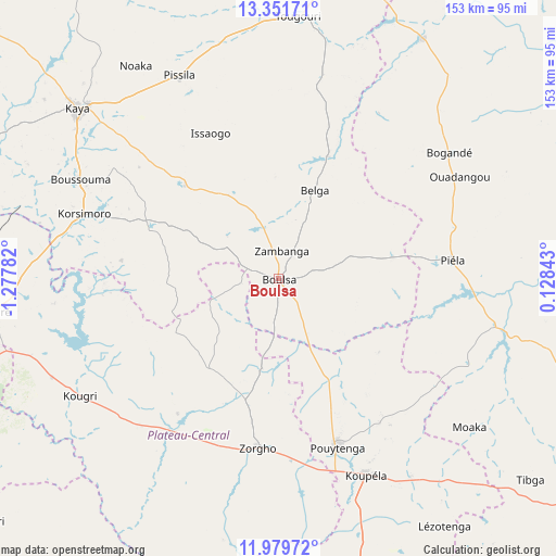
Boulsa GPS coordinates[2]
12° 39' 59.904" North, 0° 34' 28.884" West
| Map corner | latitude | longitude |
|---|---|---|
| Upper-left | 13.35171°, | -1.27782° |
| Center: | 12.66664°, | -0.57469° |
| Lower-right: | 11.97972°, | 0.12843° |
| Map W x H: | 152.6×152.6 km | = 94.8×94.8mi |
| max Lat: | 14.96549° ⇑36.7% North |
| Boulsa: | 12.66664° |
| min Lat: | ⇓63.3% South 9.88333° |
| min Long | Boulsa | max Long |
| -5.16667° | -0.57469° | 1.78838° |
| W 78.5%⇐ | ⇒21.5% E |
Elevation
Elevation of Boulsa is 313 m = 1027 ft, and this is 10 m = 33 ft above average elevation for this country.
| Max E: |
423 m = 1388 ft | 34.2% |
| Boulsa | 313 m 1027 ft | |
| Avg. | 303 m = 994 ft | |
Min E: |
222 m = 728 ft | 65.8% |
See also: Burkina Faso elevation on elevation.city.
Geographical zone
Boulsa is located in North Torrid zone (between Equator and Tropic of Cancer). Distance of this Northern Tropic circle is 1197.5 km =744.1 mi to North.| Distance of | km | miles | from Boulsa |
|---|---|---|---|
| North Pole | 8598.7 | 5343 | to North |
| Arctic Circle | 5992.8 | 3723.8 | to North |
| Tropic Cancer | 1197.5 | 744.1 | to North |
| Equator | 1408.4 | 875.1 | to South |


Nearby cities:
15 places around Boulsa: (largest is in red/bold)
• Absouya
52.1 km =32.4 mi,  266°
266°
• Bilanga
61.2 km =38 mi,  102°
102°
• Bogandé
57.1 km =35.5 mi,  53°
53°
• Boussouma
61.3 km =38.1 mi,  296°
296°
• Garango
96.4 km =59.9 mi,  178°
178°
• Kaya
72.7 km =45.2 mi,  310°
310°
• Korsimoro
56.3 km =35 mi,  288°
288°
• Koupéla
59.4 km =36.9 mi,  155°
155°
• Loumbila
88.2 km =54.8 mi,  259°
259°
• Mani
76.6 km =47.6 mi,  30°
30°
• Mané
90.8 km =56.4 mi, 293°
• Nagréongo
71.1 km =44.2 mi,  252°
252°
• Ziniaré
78.9 km =49 mi, 263°
• Zitenga
80.3 km =49.9 mi,  276°
276°
• Zorgo
46.6 km =29 mi,  185°
185°
Sources, notices
• [Note1] Compared only with cities in Burkina Faso existing in our database
• [Src1] Map data: © OpenStreetMap contributors (CC-BY-SA)
• [Src2] Other city data from geonames.org with taken over terms of usage.
• [Src3] Geographical zone / Annual Mean Temperature by Robert A. Rohde @ Wikipedia
