Kongoussi geodata
Kongoussi (Centre-Nord) is a seat of a second-order administrative division; located in Burkina Faso in Africa/Ouagadougou (GMT+0) time zone. With population of 26,338 people, there are 17 cities with bigger population in this country. Compared to other cities in Burkina Faso, 87.3% of cities are located further ↓South; 53.2% of cities are located further ←West and 83.5% of cities have lower elevation than Kongoussi. Note1


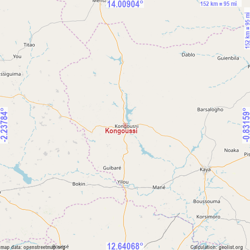
Kongoussi GPS coordinates[2]
13° 19' 32.988" North, 1° 32' 4.992" West
| Map corner | latitude | longitude |
|---|---|---|
| Upper-left | 14.00904°, | -2.23784° |
| Center: | 13.32583°, | -1.53472° |
| Lower-right: | 12.64068°, | -0.83159° |
| Map W x H: | 152.1×152.2 km | = 94.5×94.6mi |
| max Lat: | 14.96549° ⇑12.7% North |
| Kongoussi: | 13.32583° |
| min Lat: | ⇓87.3% South 9.88333° |
| min Long | Kongoussi | max Long |
| -5.16667° | -1.53472° | 1.78838° |
| W 53.2%⇐ | ⇒46.8% E |
Elevation
Elevation of Kongoussi is 330 m = 1083 ft, and this is 27 m = 89 ft above average elevation for this country.
| Max E: |
423 m = 1388 ft | 16.5% |
| Kongoussi | 330 m 1083 ft | |
| Avg. | 303 m = 994 ft | |
Min E: |
222 m = 728 ft | 83.5% |
See also: Burkina Faso elevation on elevation.city.
Geographical zone
Kongoussi is located in North Torrid zone (between Equator and Tropic of Cancer). Distance of this Northern Tropic circle is 1124.2 km =698.5 mi to North.| Distance of | km | miles | from Kongoussi |
|---|---|---|---|
| North Pole | 8525.4 | 5297.4 | to North |
| Arctic Circle | 5919.5 | 3678.2 | to North |
| Tropic Cancer | 1124.2 | 698.5 | to North |
| Equator | 1481.7 | 920.7 | to South |


Nearby cities:
15 places around Kongoussi: (largest is in red/bold)
• Boussouma
67.3 km =41.8 mi,  133°
133°
• Boussé
83.6 km =51.9 mi,  207°
207°
• Dapélogo
72.6 km =45.1 mi,  180°
180°
• Djibo
86.6 km =53.8 mi,  353°
353°
• Kaya
55.3 km =34.4 mi,  118°
118°
• Korsimoro
75.2 km =46.7 mi,  137°
137°
• Mané
42.8 km =26.6 mi,  151°
151°
• Niou
75.4 km =46.9 mi, 214°
• Ourgou-Manéga
60.8 km =37.8 mi, 177°
• Pabré
89.6 km =55.7 mi, 183°
• Titao
75.6 km =47 mi,  310°
310°
• Toéghin
60.4 km =37.5 mi,  200°
200°
• Yako
88.6 km =55.1 mi,  242°
242°
• Ziniaré
86.6 km =53.8 mi,  162°
162°
• Zitenga
68.7 km =42.7 mi, 159°
Sources, notices
• [Note1] Compared only with cities in Burkina Faso existing in our database
• [Src1] Map data: © OpenStreetMap contributors (CC-BY-SA)
• [Src2] Other city data from geonames.org with taken over terms of usage.
• [Src3] Geographical zone / Annual Mean Temperature by Robert A. Rohde @ Wikipedia
