Kaya geodata
Kaya (Centre-Nord) is a seat of a first-order administrative division; located in Burkina Faso in Africa/Ouagadougou (GMT+0) time zone. With population of 39,229 people, there are 6 cities with bigger population in this country. Compared to other cities in Burkina Faso, 82.3% of cities are located further ↓South; 69.6% of cities are located further ←West and 92.4% of cities have lower elevation than Kaya. Note1


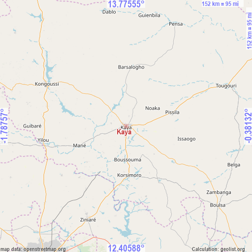
Kaya GPS coordinates[2]
13° 5' 30.012" North, 1° 5' 3.984" West
| Map corner | latitude | longitude |
|---|---|---|
| Upper-left | 13.77555°, | -1.78757° |
| Center: | 13.09167°, | -1.08444° |
| Lower-right: | 12.40588°, | -0.38132° |
| Map W x H: | 152.3×152.3 km | = 94.6×94.6mi |
| max Lat: | 14.96549° ⇑17.7% North |
| Kaya: | 13.09167° |
| min Lat: | ⇓82.3% South 9.88333° |
| min Long | Kaya | max Long |
| -5.16667° | -1.08444° | 1.78838° |
| W 69.6%⇐ | ⇒30.4% E |
Elevation
Elevation of Kaya is 341 m = 1119 ft, and this is 38 m = 125 ft above average elevation for this country.
| Max E: |
423 m = 1388 ft | 7.6% |
| Kaya | 341 m 1119 ft | |
| Avg. | 303 m = 994 ft | |
Min E: |
222 m = 728 ft | 92.4% |
See also: Burkina Faso elevation on elevation.city.
Geographical zone
Kaya is located in North Torrid zone (between Equator and Tropic of Cancer). Distance of this Northern Tropic circle is 1150.3 km =714.8 mi to North.| Distance of | km | miles | from Kaya |
|---|---|---|---|
| North Pole | 8551.4 | 5313.6 | to North |
| Arctic Circle | 5945.5 | 3694.4 | to North |
| Tropic Cancer | 1150.3 | 714.8 | to North |
| Equator | 1455.7 | 904.5 | to South |


Nearby cities:
15 places around Kaya: (largest is in red/bold)
• Absouya
50.3 km =31.3 mi,  176°
176°
• Boulsa
72.7 km =45.2 mi,  130°
130°
• Boussouma
20.1 km =12.5 mi, 179°
• Dapélogo
67.8 km =42.1 mi,  226°
226°
• Kongoussi
55.3 km =34.4 mi,  298°
298°
• Korsimoro
29.7 km =18.5 mi, 176°
• Loumbila
71 km =44.1 mi,  206°
206°
• Mané
30.4 km =18.9 mi,  247°
247°
• Nagréongo
69.3 km =43.1 mi,  190°
190°
• Ourgou-Manéga
57.5 km =35.7 mi, 232°
• Pabré
83.5 km =51.9 mi,  220°
220°
• Saaba
87.7 km =54.5 mi,  204°
204°
• Toéghin
76.1 km =47.3 mi, 246°
• Ziniaré
61.2 km =38 mi, 202°
• Zitenga
45.3 km =28.1 mi, 212°
Sources, notices
• [Note1] Compared only with cities in Burkina Faso existing in our database
• [Src1] Map data: © OpenStreetMap contributors (CC-BY-SA)
• [Src2] Other city data from geonames.org with taken over terms of usage.
• [Src3] Geographical zone / Annual Mean Temperature by Robert A. Rohde @ Wikipedia
