Boromo geodata
Boromo (Boucle du Mouhoun) is a seat of a second-order administrative division; located in Burkina Faso in Africa/Ouagadougou (GMT+0) time zone. With population of 13,157 people, there are 30 cities with bigger population in this country. Compared to other cities in Burkina Faso, 83.5% of cities are located further ↑North; 86.1% of cities are located further →East and 92.4% of cities have higher elevation than Boromo. Note1


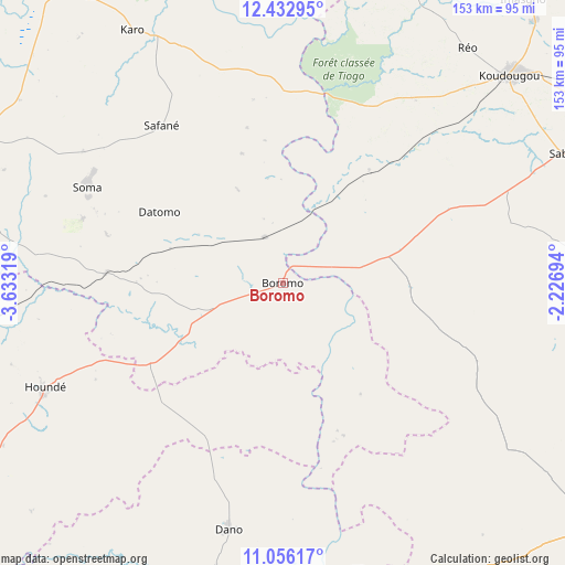
Boromo GPS coordinates[2]
11° 44' 43.512" North, 2° 55' 48.216" West
| Map corner | latitude | longitude |
|---|---|---|
| Upper-left | 12.43295°, | -3.63319° |
| Center: | 11.74542°, | -2.93006° |
| Lower-right: | 11.05617°, | -2.22694° |
| Map W x H: | 153.1×153.1 km | = 95.1×95.1mi |
| max Lat: | 14.96549° ⇑83.5% North |
| Boromo: | 11.74542° |
| min Lat: | ⇓16.5% South 9.88333° |
| min Long | Boromo | max Long |
| -5.16667° | -2.93006° | 1.78838° |
| W 13.9%⇐ | ⇒86.1% E |
Elevation
Elevation of Boromo is 263 m = 863 ft, and this is 40 m = 131 ft below average elevation for this country.
| Max E: |
423 m = 1388 ft | 92.4% |
| Avg. | 303 m = 994 ft | |
| Boromo | 263 m = 863 ft | |
Min E: |
222 m = 728 ft | 7.6% |
See also: Burkina Faso elevation on elevation.city.
Geographical zone
Boromo is located in North Torrid zone (between Equator and Tropic of Cancer). Distance of this Northern Tropic circle is 1300 km =807.8 mi to North.| Distance of | km | miles | from Boromo |
|---|---|---|---|
| North Pole | 8701.1 | 5406.6 | to North |
| Arctic Circle | 6095.2 | 3787.4 | to North |
| Tropic Cancer | 1300 | 807.8 | to North |
| Equator | 1306 | 811.5 | to South |


Nearby cities:
15 places around Boromo: (largest is in red/bold)
• Dano
68 km =42.3 mi,  191°
191°
• Diébougou
93.8 km =58.3 mi,  201°
201°
• Dédougou
98.5 km =61.2 mi,  324°
324°
• Goulouré
121.2 km =75.3 mi,  63°
63°
• Gousi
102.3 km =63.6 mi,  8°
8°
• Houndé
69.5 km =43.2 mi,  246°
246°
• Kayao
122.1 km =75.9 mi,  75°
75°
• Kokologo
124.9 km =77.6 mi,  66°
66°
• Koudougou
83.6 km =51.9 mi,  47°
47°
• Léo
114.9 km =71.4 mi,  128°
128°
• Pitmoaga
126.9 km =78.9 mi, 64°
• Réo
81 km =50.3 mi,  38°
38°
• Sapouy
127.7 km =79.3 mi,  99°
99°
• Sièn
105.4 km =65.5 mi,  1°
1°
• Toma
112.7 km =70 mi, 1°
Sources, notices
• [Note1] Compared only with cities in Burkina Faso existing in our database
• [Src1] Map data: © OpenStreetMap contributors (CC-BY-SA)
• [Src2] Other city data from geonames.org with taken over terms of usage.
• [Src3] Geographical zone / Annual Mean Temperature by Robert A. Rohde @ Wikipedia
