Dano geodata
Dano (Sud-Ouest) is a seat of a second-order administrative division; located in Burkina Faso in Africa/Ouagadougou (GMT+0) time zone. With population of 11,153 people, there are 34 cities with bigger population in this country. Compared to other cities in Burkina Faso, 93.7% of cities are located further ↑North; 87.3% of cities are located further →East and 75.9% of cities have higher elevation than Dano. Note1


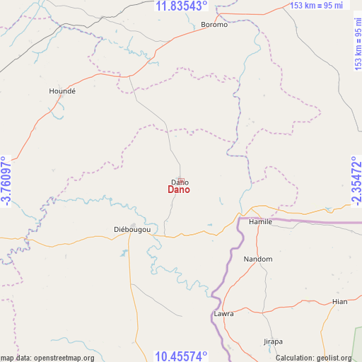
Dano GPS coordinates[2]
11° 8' 47.04" North, 3° 3' 28.224" West
| Map corner | latitude | longitude |
|---|---|---|
| Upper-left | 11.83543°, | -3.76097° |
| Center: | 11.1464°, | -3.05784° |
| Lower-right: | 10.45574°, | -2.35472° |
| Map W x H: | 153.4×153.4 km | = 95.3×95.3mi |
| max Lat: | 14.96549° ⇑93.7% North |
| Dano: | 11.1464° |
| min Lat: | ⇓6.3% South 9.88333° |
| min Long | Dano | max Long |
| -5.16667° | -3.05784° | 1.78838° |
| W 12.7%⇐ | ⇒87.3% E |
Elevation
Elevation of Dano is 285 m = 935 ft, and this is 18 m = 59 ft below average elevation for this country.
| Max E: |
423 m = 1388 ft | 75.9% |
| Avg. | 303 m = 994 ft | |
| Dano | 285 m = 935 ft | |
Min E: |
222 m = 728 ft | 24.1% |
See also: Burkina Faso elevation on elevation.city.
Geographical zone
Dano is located in North Torrid zone (between Equator and Tropic of Cancer). Distance of Equator is 1239.4 km =770.1 mi to South.| Distance of | km | miles | from Dano |
|---|---|---|---|
| North Pole | 8767.7 | 5448 | to North |
| Arctic Circle | 6161.8 | 3828.8 | to North |
| Tropic Cancer | 1366.6 | 849.2 | to North |
| Equator | 1239.4 | 770.1 | to South |


Nearby cities:
15 places around Dano: (largest is in red/bold)
• Batié
141.3 km =87.8 mi,  173°
173°
• Bobo-Dioulasso
135.3 km =84.1 mi,  271°
271°
• Boromo
68 km =42.3 mi,  11°
11°
• Diébougou
29.3 km =18.2 mi,  225°
225°
• Dédougou
152.9 km =95 mi,  343°
343°
• Goulouré
172.1 km =106.9 mi,  45°
45°
• Gousi
170.3 km =105.8 mi, 9°
• Houndé
63.6 km =39.5 mi,  308°
308°
• Kayao
163.8 km =101.8 mi, 53°
• Koudougou
144.4 km =89.7 mi,  31°
31°
• Léo
103.9 km =64.6 mi,  92°
92°
• Réo
145.3 km =90.3 mi, 26°
• Salanso
159.9 km =99.4 mi,  315°
315°
• Sapouy
147.2 km =91.5 mi,  72°
72°
• Sièn
172.8 km =107.4 mi, 5°
Sources, notices
• [Note1] Compared only with cities in Burkina Faso existing in our database
• [Src1] Map data: © OpenStreetMap contributors (CC-BY-SA)
• [Src2] Other city data from geonames.org with taken over terms of usage.
• [Src3] Geographical zone / Annual Mean Temperature by Robert A. Rohde @ Wikipedia
