Ouargaye geodata
Ouargaye (Centre-Est) is a seat of a second-order administrative division; located in Burkina Faso in Africa/Ouagadougou (GMT+0) time zone. With population of 10,103 people, there are 36 cities with bigger population in this country. Compared to other cities in Burkina Faso, 87.3% of cities are located further ↑North; 92.4% of cities are located further ←West and 68.4% of cities have higher elevation than Ouargaye. Note1


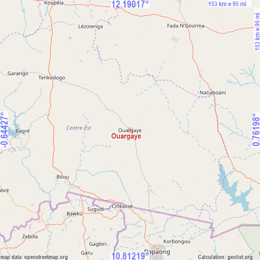
Ouargaye GPS coordinates[2]
11° 30' 7.272" North, 0° 3' 31.896" East
| Map corner | latitude | longitude |
|---|---|---|
| Upper-left | 12.19017°, | -0.64427° |
| Center: | 11.50202°, | 0.05886° |
| Lower-right: | 10.81219°, | 0.76198° |
| Map W x H: | 153.2×153.2 km | = 95.2×95.2mi |
| max Lat: | 14.96549° ⇑87.3% North |
| Ouargaye: | 11.50202° |
| min Lat: | ⇓12.7% South 9.88333° |
| min Long | Ouargaye | max Long |
| -5.16667° | 0.05886° | 1.78838° |
| W 92.4%⇐ | ⇒7.6% E |
Elevation
Elevation of Ouargaye is 292 m = 958 ft, and this is 11 m = 36 ft below average elevation for this country.
| Max E: |
423 m = 1388 ft | 68.4% |
| Avg. | 303 m = 994 ft | |
| Ouargaye | 292 m = 958 ft | |
Min E: |
222 m = 728 ft | 31.6% |
See also: Burkina Faso elevation on elevation.city.
Geographical zone
Ouargaye is located in North Torrid zone (between Equator and Tropic of Cancer). Distance of Equator is 1278.9 km =794.7 mi to South.| Distance of | km | miles | from Ouargaye |
|---|---|---|---|
| North Pole | 8728.2 | 5423.5 | to North |
| Arctic Circle | 6122.3 | 3804.2 | to North |
| Tropic Cancer | 1327 | 824.6 | to North |
| Equator | 1278.9 | 794.7 | to South |


Nearby cities:
15 places around Ouargaye: (largest is in red/bold)
• Bilanga
116.5 km =72.4 mi,  355°
355°
• Bogandé
164.8 km =102.4 mi,  352°
352°
• Boulsa
146.7 km =91.2 mi,  331°
331°
• Fada N'gourma
70.2 km =43.6 mi,  27°
27°
• Gaongo
144.4 km =89.7 mi,  292°
292°
• Garango
74.2 km =46.1 mi,  296°
296°
• Gayéri
135.9 km =84.4 mi,  20°
20°
• Kombissiri
164.4 km =102.2 mi, 292°
• Koupéla
87.5 km =54.4 mi, 329°
• Manga
124.6 km =77.4 mi,  278°
278°
• Nagréongo
174.8 km =108.6 mi,  308°
308°
• Pama
76.1 km =47.3 mi,  111°
111°
• Pô
136.3 km =84.7 mi,  254°
254°
• Tenkodogo
56 km =34.8 mi, 303°
• Zorgo
110.8 km =68.8 mi,  318°
318°
Sources, notices
• [Note1] Compared only with cities in Burkina Faso existing in our database
• [Src1] Map data: © OpenStreetMap contributors (CC-BY-SA)
• [Src2] Other city data from geonames.org with taken over terms of usage.
• [Src3] Geographical zone / Annual Mean Temperature by Robert A. Rohde @ Wikipedia
