Fada N'gourma geodata
Fada N'gourma (Est) is a seat of a first-order administrative division; located in Burkina Faso in Africa/Ouagadougou (GMT+0) time zone. With population of 33,910 people, there are 11 cities with bigger population in this country. Compared to other cities in Burkina Faso, 75.9% of cities are located further ↑North; 93.7% of cities are located further ←West and 63.3% of cities have higher elevation than Fada N'gourma. Note1


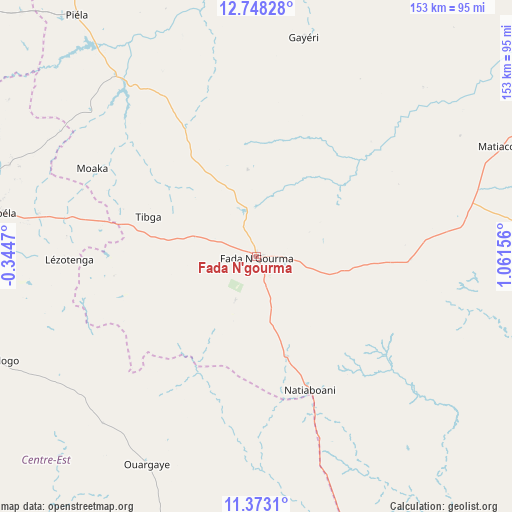
Fada N'gourma GPS coordinates[2]
12° 3' 41.652" North, 0° 21' 30.348" East
| Map corner | latitude | longitude |
|---|---|---|
| Upper-left | 12.74828°, | -0.3447° |
| Center: | 12.06157°, | 0.35843° |
| Lower-right: | 11.3731°, | 1.06156° |
| Map W x H: | 152.9×152.9 km | = 95×95mi |
| max Lat: | 14.96549° ⇑75.9% North |
| Fada N'gourma: | 12.06157° |
| min Lat: | ⇓24.1% South 9.88333° |
| min Long | Fada N'gourma | max Long |
| -5.16667° | 0.35843° | 1.78838° |
| W 93.7%⇐ | ⇒6.3% E |
Elevation
Elevation of Fada N'gourma is 298 m = 978 ft, and this is 5 m = 16 ft below average elevation for this country.
| Max E: |
423 m = 1388 ft | 63.3% |
| Avg. | 303 m = 994 ft | |
| Fada N'gourma | 298 m = 978 ft | |
Min E: |
222 m = 728 ft | 36.7% |
See also: Burkina Faso elevation on elevation.city.
Geographical zone
Fada N'gourma is located in North Torrid zone (between Equator and Tropic of Cancer). Distance of this Northern Tropic circle is 1264.8 km =785.9 mi to North.| Distance of | km | miles | from Fada N'gourma |
|---|---|---|---|
| North Pole | 8665.9 | 5384.7 | to North |
| Arctic Circle | 6060.1 | 3765.6 | to North |
| Tropic Cancer | 1264.8 | 785.9 | to North |
| Equator | 1341.1 | 833.3 | to South |


Nearby cities:
15 places around Fada N'gourma: (largest is in red/bold)
• Bilanga
68.1 km =42.3 mi,  322°
322°
• Bogandé
115.1 km =71.5 mi,  331°
331°
• Boulsa
121.6 km =75.6 mi,  303°
303°
• Boundoré
164.5 km =102.2 mi,  21°
21°
• Diapaga
155.5 km =96.6 mi,  89°
89°
• Garango
103.1 km =64.1 mi,  253°
253°
• Gayéri
66.9 km =41.6 mi,  12°
12°
• Koupéla
78.2 km =48.6 mi,  279°
279°
• Manga
161.9 km =100.6 mi, 254°
• Mani
146.8 km =91.2 mi,  335°
335°
• Ouargaye
70.2 km =43.6 mi,  207°
207°
• Pama
97.9 km =60.8 mi,  157°
157°
• Sebba
154 km =95.7 mi, 6°
• Tenkodogo
85.2 km =52.9 mi, 248°
• Zorgo
107.9 km =67 mi, 281°
Sources, notices
• [Note1] Compared only with cities in Burkina Faso existing in our database
• [Src1] Map data: © OpenStreetMap contributors (CC-BY-SA)
• [Src2] Other city data from geonames.org with taken over terms of usage.
• [Src3] Geographical zone / Annual Mean Temperature by Robert A. Rohde @ Wikipedia
