Karnobat geodata
Karnobat (Burgas) is a populated place; located in Bulgaria in Europe/Sofia (GMT+3) time zone. With population of 19,709 people, there are 46 cities with bigger population in this country. Compared to other cities in Bulgaria, 59.3% of cities are located further ↑North; 81% of cities are located further ←West and 53.3% of cities have higher elevation than Karnobat. Note1


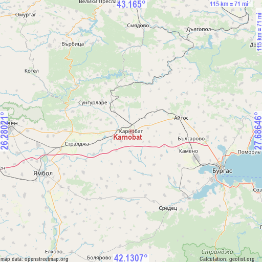
Karnobat GPS coordinates[2]
42° 39' 0" North, 26° 58' 59.988" East
| Map corner | latitude | longitude |
|---|---|---|
| Upper-left | 43.165°, | 26.28021° |
| Center: | 42.65°, | 26.98333° |
| Lower-right: | 42.1307°, | 27.68646° |
| Map W x H: | 115×115 km | = 71.5×71.5mi |
| max Lat: | 44.16214° ⇑59.3% North |
| Karnobat: | 42.65° |
| min Lat: | ⇓40.7% South 41.32715° |
| min Long | Karnobat | max Long |
| 22.52139° | 26.98333° | 28.53429° |
| W 81%⇐ | ⇒19% E |
Elevation
Elevation of Karnobat is 208 m = 682 ft, and this is 108.6 m = 356 ft below average elevation for this country.
| Max E: |
1221 m = 4006 ft | 53.3% |
| Avg. | 316.6 m = 1039 ft | |
| Karnobat | 208 m = 682 ft | |
Min E: |
1 m = 3 ft | 46.7% |
See also: Bulgaria elevation on elevation.city.
Geographical zone
Karnobat is located in North temperate zone (between Tropic of Cancer and the Arctic Circle). Distance of this Northern Tropic circle is 2136.3 km =1327.4 mi to South.| Distance of | km | miles | from Karnobat |
|---|---|---|---|
| North Pole | 5264.8 | 3271.4 | to North |
| Arctic Circle | 2658.9 | 1652.2 | to North |
| Tropic Cancer | 2136.3 | 1327.4 | to South |
| Equator | 4742.2 | 2946.7 | to South |


Nearby cities:
15 places around Karnobat: (largest is in red/bold)
• Aytos
22.5 km =14 mi,  75°
75°
• Bata
43.1 km =26.8 mi, 76°
• Burgas
42.8 km =26.6 mi,  111°
111°
• Dalgopol
53.6 km =33.3 mi,  33°
33°
• Kameno
27.3 km =17 mi, 108°
• Kotel
50.7 km =31.5 mi,  300°
300°
• Ruen
29.6 km =18.4 mi,  55°
55°
• Sarafovo
45.2 km =28.1 mi,  102°
102°
• Sliven
53.6 km =33.3 mi,  274°
274°
• Smyadovo
46.4 km =28.8 mi,  3°
3°
• Sredets
37.3 km =23.2 mi,  154°
154°
• Straldzha
25.2 km =15.7 mi,  257°
257°
• Sungurlare
20.9 km =13 mi,  308°
308°
• Varbitsa
48.3 km =30 mi,  323°
323°
• Yambol
43.7 km =27.2 mi,  244°
244°
Sources, notices
• [Note1] Compared only with cities in Bulgaria existing in our database
• [Src1] Map data: © OpenStreetMap contributors (CC-BY-SA)
• [Src2] Other city data from geonames.org with taken over terms of usage.
• [Src3] Geographical zone / Annual Mean Temperature by Robert A. Rohde @ Wikipedia
