Parakou geodata
Parakou (Borgou) is a seat of a first-order administrative division; located in Benin in Africa/Porto-Novo (GMT+1) time zone. With population of 163,753 people, there are 4 cities with bigger population in this country. Compared to other cities in Benin, 76.1% of cities are located further ↓South; 82.6% of cities are located further ←West and 87% of cities have lower elevation than Parakou. Note1


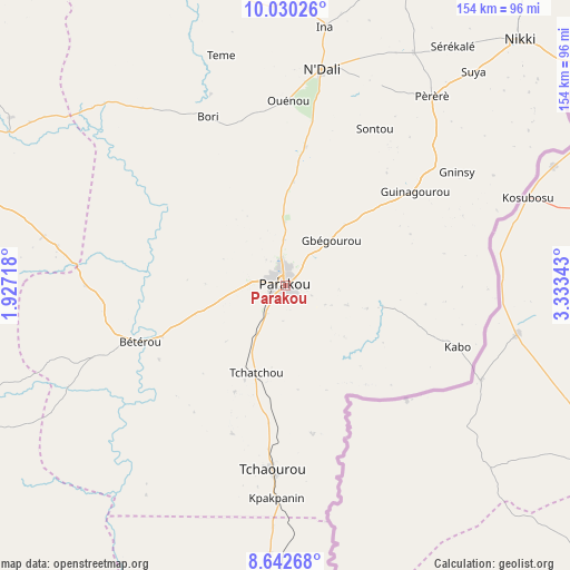
Parakou GPS coordinates[2]
9° 20' 13.776" North, 2° 37' 49.116" East
| Map corner | latitude | longitude |
|---|---|---|
| Upper-left | 10.03026°, | 1.92718° |
| Center: | 9.33716°, | 2.63031° |
| Lower-right: | 8.64268°, | 3.33343° |
| Map W x H: | 154.3×154.3 km | = 95.9×95.9mi |
| max Lat: | 11.86819° ⇑23.9% North |
| Parakou: | 9.33716° |
| min Lat: | ⇓76.1% South 6.28036° |
| min Long | Parakou | max Long |
| 1.26651° | 2.63031° | 3.38327° |
| W 82.6%⇐ | ⇒17.4% E |
Elevation
Elevation of Parakou is 369 m = 1211 ft, and this is 206.2 m = 677 ft above average elevation for this country.
| Max E: |
472 m = 1549 ft | 13% |
| Parakou | 369 m 1211 ft | |
| Avg. | 162.8 m = 534 ft | |
Min E: |
1 m = 3 ft | 87% |
See also: Parakou elevation on elevation.city.
Geographical zone
Parakou is located in North Torrid zone (between Equator and Tropic of Cancer). Distance of Equator is 1038.2 km =645.1 mi to South.| Distance of | km | miles | from Parakou |
|---|---|---|---|
| North Pole | 8968.9 | 5573 | to North |
| Arctic Circle | 6363 | 3953.8 | to North |
| Tropic Cancer | 1567.7 | 974.1 | to North |
| Equator | 1038.2 | 645.1 | to South |


Nearby cities:
15 places around Parakou: (largest is in red/bold)
• Banikoara
219.1 km =136.1 mi,  354°
354°
• Bassila
112.1 km =69.7 mi,  250°
250°
• Bembèrèkè
99.1 km =61.6 mi,  2°
2°
• Bétérou
43.6 km =27.1 mi, 249°
• Dassa-Zoumé
183.2 km =113.8 mi,  195°
195°
• Djougou
113.5 km =70.5 mi,  291°
291°
• Goumori
208.3 km =129.4 mi, 349°
• Guilmaro
168.8 km =104.9 mi,  324°
324°
• Kandi
202.6 km =125.9 mi,  9°
9°
• Natitingou
174.2 km =108.2 mi,  308°
308°
• Nikki
92.4 km =57.4 mi,  43°
43°
• Savalou
172.4 km =107.1 mi, 204°
• Savé
145.7 km =90.5 mi,  186°
186°
• Tanguiéta
206.6 km =128.4 mi, 313°
• Tchaourou
50.2 km =31.2 mi,  184°
184°
Sources, notices
• [Note1] Compared only with cities in Benin existing in our database
• [Src1] Map data: © OpenStreetMap contributors (CC-BY-SA)
• [Src2] Other city data from geonames.org with taken over terms of usage.
• [Src3] Geographical zone / Annual Mean Temperature by Robert A. Rohde @ Wikipedia
