Bembèrèkè geodata
Bembèrèkè (Borgou) is a populated place; located in Benin in Africa/Porto-Novo (GMT+1) time zone. With population of 24,006 people, there are 20 cities with bigger population in this country. Compared to other cities in Benin, 82.6% of cities are located further ↓South; 87% of cities are located further ←West and 95.7% of cities have lower elevation than Bembèrèkè. Note1


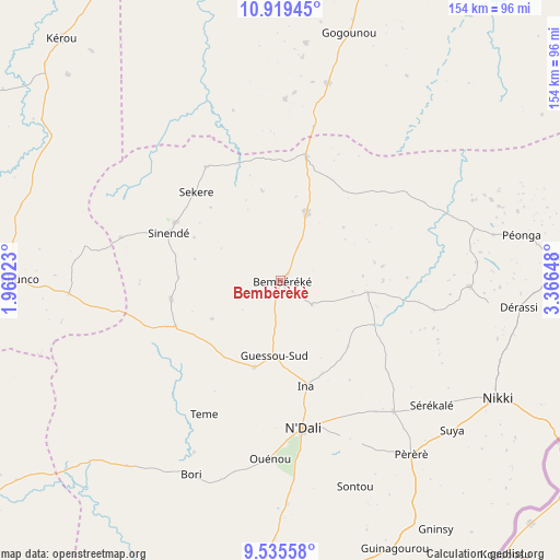
Bembèrèkè GPS coordinates[2]
10° 13' 41.772" North, 2° 39' 48.06" East
| Map corner | latitude | longitude |
|---|---|---|
| Upper-left | 10.91945°, | 1.96023° |
| Center: | 10.22827°, | 2.66335° |
| Lower-right: | 9.53558°, | 3.36648° |
| Map W x H: | 153.9×153.9 km | = 95.6×95.6mi |
| max Lat: | 11.86819° ⇑17.4% North |
| Bembèrèkè: | 10.22827° |
| min Lat: | ⇓82.6% South 6.28036° |
| min Long | Bembèrèkè | max Long |
| 1.26651° | 2.66335° | 3.38327° |
| W 87%⇐ | ⇒13% E |
Elevation
Elevation of Bembèrèkè is 445 m = 1460 ft, and this is 282.2 m = 926 ft above average elevation for this country.
| Max E: |
472 m = 1549 ft | 4.3% |
| Bembèrèkè | 445 m 1460 ft | |
| Avg. | 162.8 m = 534 ft | |
Min E: |
1 m = 3 ft | 95.7% |
See also: Benin elevation on elevation.city.
Geographical zone
Bembèrèkè is located in North Torrid zone (between Equator and Tropic of Cancer). Distance of Equator is 1137.3 km =706.7 mi to South.| Distance of | km | miles | from Bembèrèkè |
|---|---|---|---|
| North Pole | 8869.8 | 5511.4 | to North |
| Arctic Circle | 6263.9 | 3892.2 | to North |
| Tropic Cancer | 1468.6 | 912.5 | to North |
| Equator | 1137.3 | 706.7 | to South |


Nearby cities:
15 places around Bembèrèkè: (largest is in red/bold)
• Angara-Débou
129.3 km =80.3 mi,  19°
19°
• Banikoara
121.5 km =75.5 mi,  348°
348°
• Bassila
174.3 km =108.3 mi,  218°
218°
• Bétérou
122.7 km =76.2 mi,  201°
201°
• Djougou
123.6 km =76.8 mi,  242°
242°
• Goumori
113.4 km =70.5 mi,  339°
339°
• Guilmaro
109.3 km =67.9 mi,  290°
290°
• Kandi
105.1 km =65.3 mi, 16°
• Malanville
198.5 km =123.3 mi, 23°
• Natitingou
140.7 km =87.4 mi,  273°
273°
• Nikki
68 km =42.3 mi,  118°
118°
• Parakou
99.1 km =61.6 mi,  182°
182°
• Savé
244.7 km =152 mi, 184°
• Tanguiéta
158.9 km =98.7 mi, 285°
• Tchaourou
149.4 km =92.8 mi, 182°
Sources, notices
• [Note1] Compared only with cities in Benin existing in our database
• [Src1] Map data: © OpenStreetMap contributors (CC-BY-SA)
• [Src2] Other city data from geonames.org with taken over terms of usage.
• [Src3] Geographical zone / Annual Mean Temperature by Robert A. Rohde @ Wikipedia
