Djougou geodata
Djougou (Donga) is a seat of a first-order administrative division; located in Benin in Africa/Porto-Novo (GMT+1) time zone. With population of 237,040 people, there are 2 cities with bigger population in this country. Compared to other cities in Benin, 78.3% of cities are located further ↓South; 93.5% of cities are located further →East and 93.5% of cities have lower elevation than Djougou. Note1


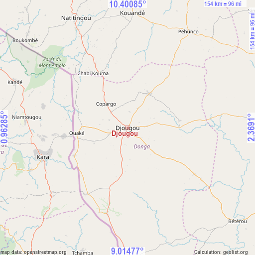
Djougou GPS coordinates[2]
9° 42' 30.708" North, 1° 39' 57.528" East
| Map corner | latitude | longitude |
|---|---|---|
| Upper-left | 10.40085°, | 0.96285° |
| Center: | 9.70853°, | 1.66598° |
| Lower-right: | 9.01477°, | 2.3691° |
| Map W x H: | 154.1×154.1 km | = 95.8×95.8mi |
| max Lat: | 11.86819° ⇑21.7% North |
| Djougou: | 9.70853° |
| min Lat: | ⇓78.3% South 6.28036° |
| min Long | Djougou | max Long |
| 1.26651° | 1.66598° | 3.38327° |
| W 6.5%⇐ | ⇒93.5% E |
Elevation
Elevation of Djougou is 444 m = 1457 ft, and this is 281.2 m = 923 ft above average elevation for this country.
| Max E: |
472 m = 1549 ft | 6.5% |
| Djougou | 444 m 1457 ft | |
| Avg. | 162.8 m = 534 ft | |
Min E: |
1 m = 3 ft | 93.5% |
See also: Djougou elevation on elevation.city.
Geographical zone
Djougou is located in North Torrid zone (between Equator and Tropic of Cancer). Distance of Equator is 1079.5 km =670.8 mi to South.| Distance of | km | miles | from Djougou |
|---|---|---|---|
| North Pole | 8927.6 | 5547.4 | to North |
| Arctic Circle | 6321.7 | 3928.1 | to North |
| Tropic Cancer | 1526.4 | 948.5 | to North |
| Equator | 1079.5 | 670.8 | to South |


Nearby cities:
15 places around Djougou: (largest is in red/bold)
• Banikoara
195.9 km =121.7 mi,  25°
25°
• Bassila
77.9 km =48.4 mi,  180°
180°
• Bembèrèkè
123.6 km =76.8 mi,  62°
62°
• Bétérou
86.2 km =53.6 mi,  131°
131°
• Dassa-Zoumé
225.1 km =139.9 mi,  165°
165°
• Goumori
177.5 km =110.3 mi,  22°
22°
• Guilmaro
95.5 km =59.3 mi,  3°
3°
• Kandi
210.9 km =131 mi,  41°
41°
• Natitingou
73.3 km =45.5 mi,  334°
334°
• Nikki
171.2 km =106.4 mi,  81°
81°
• Parakou
113.5 km =70.5 mi,  111°
111°
• Savalou
200.9 km =124.8 mi, 170°
• Savé
206.8 km =128.5 mi,  154°
154°
• Tanguiéta
110.5 km =68.7 mi,  336°
336°
• Tchaourou
137.1 km =85.2 mi, 131°
Sources, notices
• [Note1] Compared only with cities in Benin existing in our database
• [Src1] Map data: © OpenStreetMap contributors (CC-BY-SA)
• [Src2] Other city data from geonames.org with taken over terms of usage.
• [Src3] Geographical zone / Annual Mean Temperature by Robert A. Rohde @ Wikipedia
