Bétérou geodata
Bétérou (Borgou) is a populated place; located in Benin in Africa/Porto-Novo (GMT+1) time zone. With population of 13,108 people, there are 30 cities with bigger population in this country. Compared to other cities in Benin, 73.9% of cities are located further ↓South; 52.2% of cities are located further →East and 73.9% of cities have lower elevation than Bétérou. Note1


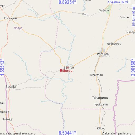
Bétérou GPS coordinates[2]
9° 11' 56.976" North, 2° 15' 30.78" East
| Map corner | latitude | longitude |
|---|---|---|
| Upper-left | 9.89254°, | 1.55543° |
| Center: | 9.19916°, | 2.25855° |
| Lower-right: | 8.50441°, | 2.96168° |
| Map W x H: | 154.3×154.3 km | = 95.9×95.9mi |
| max Lat: | 11.86819° ⇑26.1% North |
| Bétérou: | 9.19916° |
| min Lat: | ⇓73.9% South 6.28036° |
| min Long | Bétérou | max Long |
| 1.26651° | 2.25855° | 3.38327° |
| W 47.8%⇐ | ⇒52.2% E |
Elevation
Elevation of Bétérou is 259 m = 850 ft, and this is 96.2 m = 316 ft above average elevation for this country.
| Max E: |
472 m = 1549 ft | 26.1% |
| Bétérou | 259 m 850 ft | |
| Avg. | 162.8 m = 534 ft | |
Min E: |
1 m = 3 ft | 73.9% |
See also: Benin elevation on elevation.city.
Geographical zone
Bétérou is located in North Torrid zone (between Equator and Tropic of Cancer). Distance of Equator is 1022.9 km =635.6 mi to South.| Distance of | km | miles | from Bétérou |
|---|---|---|---|
| North Pole | 8984.2 | 5582.5 | to North |
| Arctic Circle | 6378.3 | 3963.3 | to North |
| Tropic Cancer | 1583.1 | 983.7 | to North |
| Equator | 1022.9 | 635.6 | to South |


Nearby cities:
15 places around Bétérou: (largest is in red/bold)
• Bassila
68.5 km =42.6 mi,  251°
251°
• Bembèrèkè
122.7 km =76.2 mi,  21°
21°
• Cové
220.1 km =136.8 mi,  177°
177°
• Dassa-Zoumé
161.3 km =100.2 mi, 182°
• Djougou
86.2 km =53.6 mi,  311°
311°
• Goumori
220.4 km =137 mi,  0°
0°
• Guilmaro
162.8 km =101.2 mi,  338°
338°
• Kétou
207.6 km =129 mi,  169°
169°
• Natitingou
156.1 km =97 mi,  321°
321°
• Nikki
133 km =82.6 mi,  51°
51°
• Parakou
43.6 km =27.1 mi,  69°
69°
• Savalou
144.7 km =89.9 mi,  192°
192°
• Savé
131.9 km =82 mi, 169°
• Tanguiéta
191.8 km =119.2 mi,  325°
325°
• Tchaourou
50.9 km =31.6 mi,  133°
133°
Sources, notices
• [Note1] Compared only with cities in Benin existing in our database
• [Src1] Map data: © OpenStreetMap contributors (CC-BY-SA)
• [Src2] Other city data from geonames.org with taken over terms of usage.
• [Src3] Geographical zone / Annual Mean Temperature by Robert A. Rohde @ Wikipedia
