Bermejo geodata
Bermejo (Tarija) is a populated place; located in Bolivia in America/La_Paz (GMT-4) time zone. With population of 35,411 people, there are 15 cities with bigger population in this country. Compared to other cities in Bolivia, 100% of cities are located further ↑North; 67.7% of cities are located further ←West and 73.9% of cities have higher elevation than Bermejo. Note1


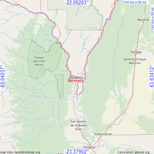
Bermejo GPS coordinates[2]
22° 43' 55.416" South, 64° 20' 14.064" West
| Map corner | latitude | longitude |
|---|---|---|
| Upper-left | -22.08203°, | -65.04037° |
| Center: | -22.73206°, | -64.33724° |
| Lower-right: | -23.37902°, | -63.63412° |
| Map W x H: | 144.2×144.2 km | = 89.6×89.6mi |
| max Lat: | -9.71828° ⇑100% North |
| Bermejo: | -22.73206° |
| min Lat: | ⇓0% South -22.73206° |
| min Long | Bermejo | max Long |
| -69.14843° | -64.33724° | -57.76667° |
| W 67.7%⇐ | ⇒32.3% E |
Elevation
Elevation of Bermejo is 416 m = 1365 ft, and this is 1595.3 m = 5234 ft below average elevation for this country.
| Max E: |
4732 m = 15525 ft | 73.9% |
| Avg. | 2011.3 m = 6599 ft | |
| Bermejo | 416 m = 1365 ft | |
Min E: |
92 m = 302 ft | 26.1% |
See also: Bolivia elevation on elevation.city.
Geographical zone
Bermejo is located in South Torrid zone (between Equator and Tropic of Capricorn). Distance of this Southern Tropic circle is 78.4 km =48.7 mi to South.| Distance of | km | miles | from Bermejo |
|---|---|---|---|
| Equator | 2527.6 | 1570.6 | to North |
| Tropic Capricorn | 78.4 | 48.7 | to South |
| Antarctic Circle | 4873.6 | 3028.3 | to South |
| South Pole | 7479.5 | 4647.5 | to South |


Nearby cities:
15 places around Bermejo: (largest is in red/bold)
• Camatindi
215.7 km =134 mi,  25°
25°
• Culpina
221.3 km =137.5 mi,  343°
343°
• Entre Ríos
135.1 km =83.9 mi,  7°
7°
• La Cueva
208.3 km =129.4 mi, 343°
• Las Carreras
191.5 km =119 mi,  329°
329°
• Las Carreras
191.8 km =119.2 mi, 332°
• Pilaya
202.7 km =126 mi,  347°
347°
• Salitre
214.1 km =133 mi, 343°
• San Francisco
227.2 km =141.2 mi, 350°
• San Juan
190.8 km =118.6 mi, 328°
• Tarija
139 km =86.4 mi, 343°
• Tupiza
202 km =125.5 mi,  315°
315°
• Villamontes
186.3 km =115.8 mi, 28°
• Villazón
147.8 km =91.8 mi,  299°
299°
• Yacuiba
104.6 km =65 mi,  40°
40°
Sources, notices
• [Note1] Compared only with cities in Bolivia existing in our database
• [Src1] Map data: © OpenStreetMap contributors (CC-BY-SA)
• [Src2] Other city data from geonames.org with taken over terms of usage.
• [Src3] Geographical zone / Annual Mean Temperature by Robert A. Rohde @ Wikipedia
