Yacuiba geodata
Yacuiba (Tarija) is a seat of a second-order administrative division; located in Bolivia in America/La_Paz (GMT-4) time zone. With population of 82,803 people, there are 11 cities with bigger population in this country. Compared to other cities in Bolivia, 98.8% of cities are located further ↑North; 75.8% of cities are located further ←West and 67.7% of cities have higher elevation than Yacuiba. Note1


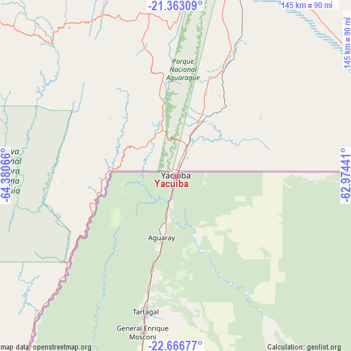
Yacuiba GPS coordinates[2]
22° 0' 59.148" South, 63° 40' 39.108" West
| Map corner | latitude | longitude |
|---|---|---|
| Upper-left | -21.36309°, | -64.38066° |
| Center: | -22.01643°, | -63.67753° |
| Lower-right: | -22.66677°, | -62.97441° |
| Map W x H: | 145×145 km | = 90.1×90.1mi |
| max Lat: | -9.71828° ⇑98.8% North |
| Yacuiba: | -22.01643° |
| min Lat: | ⇓1.2% South -22.73206° |
| min Long | Yacuiba | max Long |
| -69.14843° | -63.67753° | -57.76667° |
| W 75.8%⇐ | ⇒24.2% E |
Elevation
Elevation of Yacuiba is 629 m = 2064 ft, and this is 1382.3 m = 4535 ft below average elevation for this country.
| Max E: |
4732 m = 15525 ft | 67.7% |
| Avg. | 2011.3 m = 6599 ft | |
| Yacuiba | 629 m = 2064 ft | |
Min E: |
92 m = 302 ft | 32.3% |
See also: Yacuiba elevation on elevation.city.
Geographical zone
Yacuiba is located in South Torrid zone (between Equator and Tropic of Capricorn). Distance of this Southern Tropic circle is 157.9 km =98.1 mi to South.| Distance of | km | miles | from Yacuiba |
|---|---|---|---|
| Equator | 2448 | 1521.1 | to North |
| Tropic Capricorn | 157.9 | 98.1 | to South |
| Antarctic Circle | 4953.2 | 3077.8 | to South |
| South Pole | 7559.1 | 4697 | to South |


Nearby cities:
15 places around Yacuiba: (largest is in red/bold)
• Bermejo
104.6 km =65 mi,  220°
220°
• Boyuibe
180.9 km =112.4 mi,  13°
13°
• Camatindi
117.6 km =73.1 mi, 12°
• Carandayti
154.4 km =95.9 mi,  24°
24°
• Culpina
186.5 km =115.9 mi,  315°
315°
• Entre Ríos
74.7 km =46.4 mi, 316°
• Huajlaya
181.6 km =112.8 mi,  330°
330°
• La Cueva
174.6 km =108.5 mi,  313°
313°
• Las Carreras
182.1 km =113.2 mi,  299°
299°
• Pilaya
162.4 km =100.9 mi, 316°
• Rosario del Ingre
161 km =100 mi,  351°
351°
• Salitre
179.8 km =111.7 mi, 314°
• San Francisco
179.1 km =111.3 mi, 323°
• Tarija
121.1 km =75.2 mi, 296°
• Villamontes
86.6 km =53.8 mi, 14°
Sources, notices
• [Note1] Compared only with cities in Bolivia existing in our database
• [Src1] Map data: © OpenStreetMap contributors (CC-BY-SA)
• [Src2] Other city data from geonames.org with taken over terms of usage.
• [Src3] Geographical zone / Annual Mean Temperature by Robert A. Rohde @ Wikipedia
