Três Lagoas geodata
Três Lagoas (Mato Grosso do Sul) is a populated place; located in Brazil in America/Campo_Grande (GMT-4) time zone. With population of 78,712 people, there are 290 cities with bigger population in this country. Compared to other cities in Brazil, 61.7% of cities are located further ↑North; 86.4% of cities are located further →East and 51.8% of cities have higher elevation than Três Lagoas. Note1


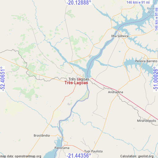
Três Lagoas GPS coordinates[2]
20° 47' 15.54" South, 51° 42' 12.168" West
| Map corner | latitude | longitude |
|---|---|---|
| Upper-left | -20.12888°, | -52.40651° |
| Center: | -20.78765°, | -51.70338° |
| Lower-right: | -21.44356°, | -51.00026° |
| Map W x H: | 146.2×146.2 km | = 90.8×90.8mi |
| max Lat: | 2.81972° ⇑61.7% North |
| Três Lagoas: | -20.78765° |
| min Lat: | ⇓38.3% South -33.69111° |
| min Long | Três Lagoas | max Long |
| -72.89583° | -51.70338° | -32.41083° |
| W 13.6%⇐ | ⇒86.4% E |
Elevation
Elevation of Três Lagoas is 328 m = 1076 ft, and this is 52.9 m = 174 ft below average elevation for this country.
| Max E: |
1603 m = 5259 ft | 51.8% |
| Avg. | 380.9 m = 1250 ft | |
| Três Lagoas | 328 m = 1076 ft | |
Min E: |
0 m = 0 ft | 48.2% |
See also: Três Lagoas elevation on elevation.city.
Geographical zone
Três Lagoas is located in South Torrid zone (between Equator and Tropic of Capricorn). Distance of this Southern Tropic circle is 294.5 km =183 mi to South.| Distance of | km | miles | from Três Lagoas |
|---|---|---|---|
| Equator | 2311.4 | 1436.2 | to North |
| Tropic Capricorn | 294.5 | 183 | to South |
| Antarctic Circle | 5089.8 | 3162.7 | to South |
| South Pole | 7695.7 | 4781.9 | to South |


Nearby cities:
15 places around Três Lagoas: (largest is in red/bold)
• Andradina
35.8 km =22.2 mi,  109°
109°
• Aparecida do Taboado
100.6 km =62.5 mi,  39°
39°
• Castilho
24.3 km =15.1 mi, 112°
• Ilha Solteira
54.5 km =33.9 mi, 43°
• Junqueirópolis
85.5 km =53.1 mi,  160°
160°
• Mirandopólis
73.4 km =45.6 mi,  121°
121°
• Pacaembu
97.6 km =60.6 mi,  151°
151°
• Panorama
65.3 km =40.6 mi,  194°
194°
• Paulista Flórida
104.3 km =64.8 mi, 149°
• Pereira Barreto
64 km =39.8 mi,  74°
74°
• Presidente Epitácio
116.6 km =72.5 mi,  201°
201°
• Santa Fé do Sul
103.3 km =64.2 mi,  51°
51°
• Santo Anastácio
117.2 km =72.8 mi,  175°
175°
• Tupi Paulista
67.4 km =41.9 mi,  168°
168°
• Valparaíso
99.5 km =61.8 mi, 119°
Sources, notices
• [Note1] Compared only with cities in Brazil existing in our database
• [Src1] Map data: © OpenStreetMap contributors (CC-BY-SA)
• [Src2] Other city data from geonames.org with taken over terms of usage.
• [Src3] Geographical zone / Annual Mean Temperature by Robert A. Rohde @ Wikipedia
