Castilho geodata
Castilho (São Paulo) is a populated place; located in Brazil in America/Sao_Paulo (GMT-3) time zone. With population of 11,419 people, there are 1528 cities with bigger population in this country. Compared to other cities in Brazil, 62.2% of cities are located further ↑North; 85.4% of cities are located further →East and 52.3% of cities have lower elevation than Castilho. Note1


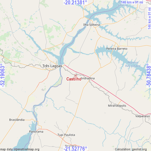
Castilho GPS coordinates[2]
20° 52' 19.992" South, 51° 29' 15" West
| Map corner | latitude | longitude |
|---|---|---|
| Upper-left | -20.21381°, | -52.19063° |
| Center: | -20.87222°, | -51.4875° |
| Lower-right: | -21.52776°, | -50.78438° |
| Map W x H: | 146.1×146.1 km | = 90.8×90.8mi |
| max Lat: | 2.81972° ⇑62.2% North |
| Castilho: | -20.87222° |
| min Lat: | ⇓37.8% South -33.69111° |
| min Long | Castilho | max Long |
| -72.89583° | -51.4875° | -32.41083° |
| W 14.6%⇐ | ⇒85.4% E |
Elevation
Elevation of Castilho is 382 m = 1253 ft, and this is 1.1 m = 4 ft above average elevation for this country.
| Max E: |
1603 m = 5259 ft | 47.7% |
| Castilho | 382 m 1253 ft | |
| Avg. | 380.9 m = 1250 ft | |
Min E: |
0 m = 0 ft | 52.3% |
See also: Brazil elevation on elevation.city.
Geographical zone
Castilho is located in South Torrid zone (between Equator and Tropic of Capricorn). Distance of this Southern Tropic circle is 285.1 km =177.2 mi to South.| Distance of | km | miles | from Castilho |
|---|---|---|---|
| Equator | 2320.8 | 1442.1 | to North |
| Tropic Capricorn | 285.1 | 177.2 | to South |
| Antarctic Circle | 5080.4 | 3156.8 | to South |
| South Pole | 7686.3 | 4776 | to South |


Nearby cities:
15 places around Castilho: (largest is in red/bold)
• Andradina
11.5 km =7.1 mi,  103°
103°
• Aparecida do Taboado
96.5 km =60 mi,  25°
25°
• Auriflama
99.2 km =61.6 mi,  77°
77°
• Guararapes
97.7 km =60.7 mi,  116°
116°
• Ilha Solteira
51.1 km =31.8 mi,  17°
17°
• Junqueirópolis
71.7 km =44.6 mi,  175°
175°
• Mirandopólis
49.5 km =30.8 mi,  125°
125°
• Pacaembu
80.2 km =49.8 mi,  162°
162°
• Panorama
66.2 km =41.1 mi,  215°
215°
• Paulista Flórida
86.2 km =53.6 mi, 159°
• Pereira Barreto
47.2 km =29.3 mi,  56°
56°
• Santa Fé do Sul
93.9 km =58.3 mi,  38°
38°
• Três Lagoas
24.3 km =15.1 mi,  292°
292°
• Tupi Paulista
57.2 km =35.5 mi,  188°
188°
• Valparaíso
75.4 km =46.9 mi, 121°
Sources, notices
• [Note1] Compared only with cities in Brazil existing in our database
• [Src1] Map data: © OpenStreetMap contributors (CC-BY-SA)
• [Src2] Other city data from geonames.org with taken over terms of usage.
• [Src3] Geographical zone / Annual Mean Temperature by Robert A. Rohde @ Wikipedia
