Andradina geodata
Andradina (São Paulo) is a populated place; located in Brazil in America/Sao_Paulo (GMT-3) time zone. With population of 52,406 people, there are 412 cities with bigger population in this country. Compared to other cities in Brazil, 62.4% of cities are located further ↑North; 84.9% of cities are located further →East and 54.7% of cities have lower elevation than Andradina. Note1


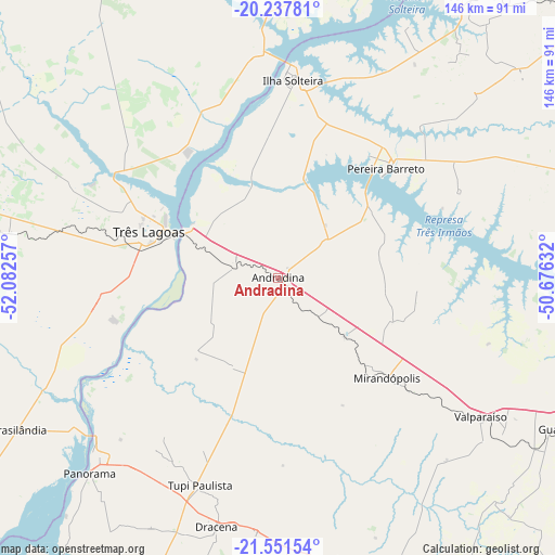
Andradina GPS coordinates[2]
20° 53' 45.996" South, 51° 22' 45.984" West
| Map corner | latitude | longitude |
|---|---|---|
| Upper-left | -20.23781°, | -52.08257° |
| Center: | -20.89611°, | -51.37944° |
| Lower-right: | -21.55154°, | -50.67632° |
| Map W x H: | 146.1×146.1 km | = 90.8×90.8mi |
| max Lat: | 2.81972° ⇑62.4% North |
| Andradina: | -20.89611° |
| min Lat: | ⇓37.6% South -33.69111° |
| min Long | Andradina | max Long |
| -72.89583° | -51.37944° | -32.41083° |
| W 15.1%⇐ | ⇒84.9% E |
Elevation
Elevation of Andradina is 417 m = 1368 ft, and this is 36.1 m = 118 ft above average elevation for this country.
| Max E: |
1603 m = 5259 ft | 45.3% |
| Andradina | 417 m 1368 ft | |
| Avg. | 380.9 m = 1250 ft | |
Min E: |
0 m = 0 ft | 54.7% |
See also: Andradina elevation on elevation.city.
Geographical zone
Andradina is located in South Torrid zone (between Equator and Tropic of Capricorn). Distance of this Southern Tropic circle is 282.5 km =175.5 mi to South.| Distance of | km | miles | from Andradina |
|---|---|---|---|
| Equator | 2323.4 | 1443.7 | to North |
| Tropic Capricorn | 282.5 | 175.5 | to South |
| Antarctic Circle | 5077.7 | 3155.1 | to South |
| South Pole | 7683.6 | 4774.4 | to South |


Nearby cities:
15 places around Andradina: (largest is in red/bold)
• Adamantina
93.3 km =58 mi,  160°
160°
• Auriflama
88.9 km =55.2 mi,  74°
74°
• Castilho
11.5 km =7.1 mi,  283°
283°
• Guararapes
86.5 km =53.7 mi,  117°
117°
• Ilha Solteira
51.7 km =32.1 mi,  4°
4°
• Junqueirópolis
69 km =42.9 mi,  184°
184°
• Mirandopólis
39.1 km =24.3 mi,  132°
132°
• Pacaembu
75.1 km =46.7 mi,  170°
170°
• Panorama
71.4 km =44.4 mi,  224°
224°
• Paulista Flórida
80.4 km =50 mi, 166°
• Pereira Barreto
40.1 km =24.9 mi,  44°
44°
• Santa Fé do Sul
89.6 km =55.7 mi,  31°
31°
• Três Lagoas
35.8 km =22.2 mi,  289°
289°
• Tupi Paulista
57.5 km =35.7 mi,  200°
200°
• Valparaíso
64.6 km =40.1 mi, 124°
Sources, notices
• [Note1] Compared only with cities in Brazil existing in our database
• [Src1] Map data: © OpenStreetMap contributors (CC-BY-SA)
• [Src2] Other city data from geonames.org with taken over terms of usage.
• [Src3] Geographical zone / Annual Mean Temperature by Robert A. Rohde @ Wikipedia
