Ilha Solteira geodata
Ilha Solteira (São Paulo) is a populated place; located in Brazil in America/Sao_Paulo (GMT-3) time zone. With population of 24,997 people, there are 782 cities with bigger population in this country. Compared to other cities in Brazil, 59.6% of cities are located further ↑North; 84.7% of cities are located further →East and 51.6% of cities have lower elevation than Ilha Solteira. Note1


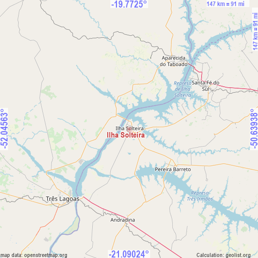
Ilha Solteira GPS coordinates[2]
20° 25' 58.008" South, 51° 20' 33" West
| Map corner | latitude | longitude |
|---|---|---|
| Upper-left | -19.7725°, | -52.04563° |
| Center: | -20.43278°, | -51.3425° |
| Lower-right: | -21.09024°, | -50.63938° |
| Map W x H: | 146.5×146.5 km | = 91×91mi |
| max Lat: | 2.81972° ⇑59.6% North |
| Ilha Solteira: | -20.43278° |
| min Lat: | ⇓40.4% South -33.69111° |
| min Long | Ilha Solteira | max Long |
| -72.89583° | -51.3425° | -32.41083° |
| W 15.3%⇐ | ⇒84.7% E |
Elevation
Elevation of Ilha Solteira is 372 m = 1220 ft, and this is 8.9 m = 29 ft below average elevation for this country.
| Max E: |
1603 m = 5259 ft | 48.4% |
| Avg. | 380.9 m = 1250 ft | |
| Ilha Solteira | 372 m = 1220 ft | |
Min E: |
0 m = 0 ft | 51.6% |
See also: Brazil elevation on elevation.city.
Geographical zone
Ilha Solteira is located in South Torrid zone (between Equator and Tropic of Capricorn). Distance of this Southern Tropic circle is 334 km =207.5 mi to South.| Distance of | km | miles | from Ilha Solteira |
|---|---|---|---|
| Equator | 2271.9 | 1411.7 | to North |
| Tropic Capricorn | 334 | 207.5 | to South |
| Antarctic Circle | 5129.3 | 3187.2 | to South |
| South Pole | 7735.1 | 4806.4 | to South |


Nearby cities:
15 places around Ilha Solteira: (largest is in red/bold)
• Andradina
51.7 km =32.1 mi,  184°
184°
• Aparecida do Taboado
46.4 km =28.8 mi,  34°
34°
• Auriflama
86.7 km =53.9 mi,  108°
108°
• Castilho
51.1 km =31.8 mi,  197°
197°
• Fernandópolis
115.5 km =71.8 mi,  81°
81°
• General Salgado
105 km =65.2 mi,  103°
103°
• Jales
85 km =52.8 mi, 77°
• Mirandopólis
81.8 km =50.8 mi,  162°
162°
• Panorama
115.9 km =72 mi,  207°
207°
• Paranaíba
85.5 km =53.1 mi,  10°
10°
• Pereira Barreto
33.4 km =20.8 mi,  133°
133°
• Santa Fé do Sul
50 km =31.1 mi,  60°
60°
• Três Lagoas
54.5 km =33.9 mi,  223°
223°
• Tupi Paulista
108.1 km =67.2 mi,  192°
192°
• Valparaíso
101.2 km =62.9 mi,  150°
150°
Sources, notices
• [Note1] Compared only with cities in Brazil existing in our database
• [Src1] Map data: © OpenStreetMap contributors (CC-BY-SA)
• [Src2] Other city data from geonames.org with taken over terms of usage.
• [Src3] Geographical zone / Annual Mean Temperature by Robert A. Rohde @ Wikipedia
