Votuporanga geodata
Votuporanga (São Paulo) is a populated place; located in Brazil in America/Sao_Paulo (GMT-3) time zone. With population of 69,863 people, there are 326 cities with bigger population in this country. Compared to other cities in Brazil, 59.5% of cities are located further ↑North; 78.2% of cities are located further →East and 65.3% of cities have lower elevation than Votuporanga. Note1


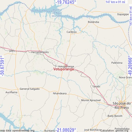
Votuporanga GPS coordinates[2]
20° 25' 22.008" South, 49° 58' 22.008" West
| Map corner | latitude | longitude |
|---|---|---|
| Upper-left | -19.76245°, | -50.67591° |
| Center: | -20.42278°, | -49.97278° |
| Lower-right: | -21.08029°, | -49.26966° |
| Map W x H: | 146.5×146.5 km | = 91×91mi |
| max Lat: | 2.81972° ⇑59.5% North |
| Votuporanga: | -20.42278° |
| min Lat: | ⇓40.5% South -33.69111° |
| min Long | Votuporanga | max Long |
| -72.89583° | -49.97278° | -32.41083° |
| W 21.8%⇐ | ⇒78.2% E |
Elevation
Elevation of Votuporanga is 528 m = 1732 ft, and this is 147.1 m = 483 ft above average elevation for this country.
| Max E: |
1603 m = 5259 ft | 34.7% |
| Votuporanga | 528 m 1732 ft | |
| Avg. | 380.9 m = 1250 ft | |
Min E: |
0 m = 0 ft | 65.3% |
See also: Votuporanga elevation on elevation.city.
Geographical zone
Votuporanga is located in South Torrid zone (between Equator and Tropic of Capricorn). Distance of this Southern Tropic circle is 335.1 km =208.2 mi to South.| Distance of | km | miles | from Votuporanga |
|---|---|---|---|
| Equator | 2270.8 | 1411 | to North |
| Tropic Capricorn | 335.1 | 208.2 | to South |
| Antarctic Circle | 5130.4 | 3187.9 | to South |
| South Pole | 7736.3 | 4807.1 | to South |


Nearby cities:
15 places around Votuporanga: (largest is in red/bold)
• Auriflama
67.3 km =41.8 mi,  244°
244°
• Bady Bassitt
77.7 km =48.3 mi,  135°
135°
• Buritama
73.8 km =45.9 mi,  194°
194°
• Cardoso
38.4 km =23.9 mi,  9°
9°
• Fernandópolis
32.4 km =20.1 mi,  298°
298°
• General Salgado
47.5 km =29.5 mi, 238°
• Iturama
80.7 km =50.1 mi,  343°
343°
• Jales
62.1 km =38.6 mi,  285°
285°
• José Bonifácio
76 km =47.2 mi,  157°
157°
• Monte Aprazível
47.3 km =29.4 mi,  145°
145°
• Nhandeara
30.5 km =19 mi, 193°
• Nova Granada
69.7 km =43.3 mi,  100°
100°
• Riolândia
57.8 km =35.9 mi,  31°
31°
• São José do Rio Preto
75.9 km =47.2 mi,  125°
125°
• Tanabi
40.6 km =25.2 mi,  123°
123°
Sources, notices
• [Note1] Compared only with cities in Brazil existing in our database
• [Src1] Map data: © OpenStreetMap contributors (CC-BY-SA)
• [Src2] Other city data from geonames.org with taken over terms of usage.
• [Src3] Geographical zone / Annual Mean Temperature by Robert A. Rohde @ Wikipedia
