Fernandópolis geodata
Fernandópolis (São Paulo) is a populated place; located in Brazil in America/Sao_Paulo (GMT-3) time zone. With population of 61,931 people, there are 362 cities with bigger population in this country. Compared to other cities in Brazil, 58.7% of cities are located further ↑North; 79.4% of cities are located further →East and 66.1% of cities have lower elevation than Fernandópolis. Note1


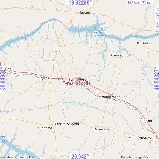
Fernandópolis GPS coordinates[2]
20° 17' 2.004" South, 50° 14' 47.004" West
| Map corner | latitude | longitude |
|---|---|---|
| Upper-left | -19.62298°, | -50.94952° |
| Center: | -20.28389°, | -50.24639° |
| Lower-right: | -20.942°, | -49.54327° |
| Map W x H: | 146.7×146.7 km | = 91.2×91.2mi |
| max Lat: | 2.81972° ⇑58.7% North |
| Fernandópolis: | -20.28389° |
| min Lat: | ⇓41.3% South -33.69111° |
| min Long | Fernandópolis | max Long |
| -72.89583° | -50.24639° | -32.41083° |
| W 20.6%⇐ | ⇒79.4% E |
Elevation
Elevation of Fernandópolis is 533 m = 1749 ft, and this is 152.1 m = 499 ft above average elevation for this country.
| Max E: |
1603 m = 5259 ft | 33.9% |
| Fernandópolis | 533 m 1749 ft | |
| Avg. | 380.9 m = 1250 ft | |
Min E: |
0 m = 0 ft | 66.1% |
See also: Fernandópolis elevation on elevation.city.
Geographical zone
Fernandópolis is located in South Torrid zone (between Equator and Tropic of Capricorn). Distance of this Southern Tropic circle is 350.6 km =217.9 mi to South.| Distance of | km | miles | from Fernandópolis |
|---|---|---|---|
| Equator | 2255.4 | 1401.4 | to North |
| Tropic Capricorn | 350.6 | 217.9 | to South |
| Antarctic Circle | 5145.8 | 3197.5 | to South |
| South Pole | 7751.7 | 4816.7 | to South |


Nearby cities:
15 places around Fernandópolis: (largest is in red/bold)
• Aparecida do Taboado
91.1 km =56.6 mi,  283°
283°
• Auriflama
55 km =34.2 mi,  215°
215°
• Buritama
87.6 km =54.4 mi,  173°
173°
• Cardoso
41.3 km =25.7 mi,  57°
57°
• General Salgado
42.2 km =26.2 mi,  196°
196°
• Iturama
62 km =38.5 mi,  4°
4°
• Jales
31.3 km =19.4 mi,  273°
273°
• Monte Aprazível
77.6 km =48.2 mi,  134°
134°
• Nhandeara
49.9 km =31 mi,  154°
154°
• Nova Granada
101 km =62.8 mi,  105°
105°
• Pereira Barreto
98.1 km =61 mi,  246°
246°
• Riolândia
67.9 km =42.2 mi, 60°
• Santa Fé do Sul
71.3 km =44.3 mi, 276°
• Tanabi
72.9 km =45.3 mi,  121°
121°
• Votuporanga
32.4 km =20.1 mi, 118°
Sources, notices
• [Note1] Compared only with cities in Brazil existing in our database
• [Src1] Map data: © OpenStreetMap contributors (CC-BY-SA)
• [Src2] Other city data from geonames.org with taken over terms of usage.
• [Src3] Geographical zone / Annual Mean Temperature by Robert A. Rohde @ Wikipedia
