Cardoso geodata
Cardoso (São Paulo) is a populated place; located in Brazil in America/Sao_Paulo (GMT-3) time zone. With population of 10,556 people, there are 1597 cities with bigger population in this country. Compared to other cities in Brazil, 57.7% of cities are located further ↑North; 77.6% of cities are located further →East and 55.9% of cities have lower elevation than Cardoso. Note1


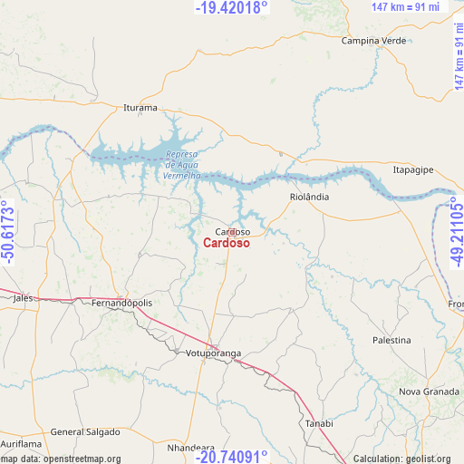
Cardoso GPS coordinates[2]
20° 4' 54.984" South, 49° 54' 51.012" West
| Map corner | latitude | longitude |
|---|---|---|
| Upper-left | -19.42018°, | -50.6173° |
| Center: | -20.08194°, | -49.91417° |
| Lower-right: | -20.74091°, | -49.21105° |
| Map W x H: | 146.9×146.9 km | = 91.3×91.3mi |
| max Lat: | 2.81972° ⇑57.7% North |
| Cardoso: | -20.08194° |
| min Lat: | ⇓42.3% South -33.69111° |
| min Long | Cardoso | max Long |
| -72.89583° | -49.91417° | -32.41083° |
| W 22.4%⇐ | ⇒77.6% E |
Elevation
Elevation of Cardoso is 429 m = 1407 ft, and this is 48.1 m = 158 ft above average elevation for this country.
| Max E: |
1603 m = 5259 ft | 44.1% |
| Cardoso | 429 m 1407 ft | |
| Avg. | 380.9 m = 1250 ft | |
Min E: |
0 m = 0 ft | 55.9% |
See also: Brazil elevation on elevation.city.
Geographical zone
Cardoso is located in South Torrid zone (between Equator and Tropic of Capricorn). Distance of this Southern Tropic circle is 373 km =231.8 mi to South.| Distance of | km | miles | from Cardoso |
|---|---|---|---|
| Equator | 2232.9 | 1387.5 | to North |
| Tropic Capricorn | 373 | 231.8 | to South |
| Antarctic Circle | 5168.3 | 3211.4 | to South |
| South Pole | 7774.2 | 4830.7 | to South |


Nearby cities:
15 places around Cardoso: (largest is in red/bold)
• Auriflama
94.7 km =58.8 mi,  224°
224°
• Bady Bassitt
105 km =65.2 mi,  152°
152°
• Campina Verde
75.1 km =46.7 mi,  36°
36°
• Fernandópolis
41.3 km =25.7 mi,  237°
237°
• Frutal
101.9 km =63.3 mi,  86°
86°
• General Salgado
78.3 km =48.7 mi, 216°
• Iturama
49.1 km =30.5 mi,  323°
323°
• Jales
69.1 km =42.9 mi,  252°
252°
• Monte Aprazível
79.6 km =49.5 mi,  164°
164°
• Nhandeara
68.9 km =42.8 mi,  191°
191°
• Nova Granada
80.2 km =49.8 mi,  128°
128°
• Riolândia
26.7 km =16.6 mi,  65°
65°
• São José do Rio Preto
99.2 km =61.6 mi, 145°
• Tanabi
66.5 km =41.3 mi, 155°
• Votuporanga
38.4 km =23.9 mi, 189°
Sources, notices
• [Note1] Compared only with cities in Brazil existing in our database
• [Src1] Map data: © OpenStreetMap contributors (CC-BY-SA)
• [Src2] Other city data from geonames.org with taken over terms of usage.
• [Src3] Geographical zone / Annual Mean Temperature by Robert A. Rohde @ Wikipedia
