Nhandeara geodata
Nhandeara (São Paulo) is a populated place; located in Brazil in America/Sao_Paulo (GMT-3) time zone. With population of 10,000 people, there are 1652 cities with bigger population in this country. Compared to other cities in Brazil, 61.1% of cities are located further ↑North; 78.5% of cities are located further →East and 63.6% of cities have lower elevation than Nhandeara. Note1


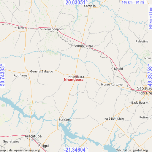
Nhandeara GPS coordinates[2]
20° 41' 22.92" South, 50° 2' 26.52" West
| Map corner | latitude | longitude |
|---|---|---|
| Upper-left | -20.03051°, | -50.74383° |
| Center: | -20.6897°, | -50.0407° |
| Lower-right: | -21.34604°, | -49.33758° |
| Map W x H: | 146.3×146.3 km | = 90.9×90.9mi |
| max Lat: | 2.81972° ⇑61.1% North |
| Nhandeara: | -20.6897° |
| min Lat: | ⇓38.9% South -33.69111° |
| min Long | Nhandeara | max Long |
| -72.89583° | -50.0407° | -32.41083° |
| W 21.5%⇐ | ⇒78.5% E |
Elevation
Elevation of Nhandeara is 514 m = 1686 ft, and this is 133.1 m = 437 ft above average elevation for this country.
| Max E: |
1603 m = 5259 ft | 36.4% |
| Nhandeara | 514 m 1686 ft | |
| Avg. | 380.9 m = 1250 ft | |
Min E: |
0 m = 0 ft | 63.6% |
See also: Brazil elevation on elevation.city.
Geographical zone
Nhandeara is located in South Torrid zone (between Equator and Tropic of Capricorn). Distance of this Southern Tropic circle is 305.4 km =189.8 mi to South.| Distance of | km | miles | from Nhandeara |
|---|---|---|---|
| Equator | 2300.5 | 1429.5 | to North |
| Tropic Capricorn | 305.4 | 189.8 | to South |
| Antarctic Circle | 5100.7 | 3169.4 | to South |
| South Pole | 7706.6 | 4788.7 | to South |


Nearby cities:
15 places around Nhandeara: (largest is in red/bold)
• Araçatuba
70.6 km =43.9 mi,  215°
215°
• Auriflama
53.5 km =33.2 mi,  270°
270°
• Bady Bassitt
66.9 km =41.6 mi,  112°
112°
• Birigui
73.5 km =45.7 mi,  205°
205°
• Buritama
43.3 km =26.9 mi,  194°
194°
• Cardoso
68.9 km =42.8 mi,  11°
11°
• Fernandópolis
49.9 km =31 mi,  334°
334°
• General Salgado
33.6 km =20.9 mi,  277°
277°
• Jales
70.4 km =43.7 mi,  311°
311°
• José Bonifácio
54.5 km =33.9 mi,  137°
137°
• Monte Aprazível
35.2 km =21.9 mi, 105°
• Nova Granada
77.6 km =48.2 mi,  77°
77°
• São José do Rio Preto
70.3 km =43.7 mi,  101°
101°
• Tanabi
41.3 km =25.7 mi, 80°
• Votuporanga
30.5 km =19 mi, 13°
Sources, notices
• [Note1] Compared only with cities in Brazil existing in our database
• [Src1] Map data: © OpenStreetMap contributors (CC-BY-SA)
• [Src2] Other city data from geonames.org with taken over terms of usage.
• [Src3] Geographical zone / Annual Mean Temperature by Robert A. Rohde @ Wikipedia
