Pedra Azul geodata
Pedra Azul (Minas Gerais) is a populated place; located in Brazil in America/Sao_Paulo (GMT-3) time zone. With population of 20,899 people, there are 910 cities with bigger population in this country. Compared to other cities in Brazil, 53.4% of cities are located further ↓South; 69.1% of cities are located further ←West and 79% of cities have lower elevation than Pedra Azul. Note1


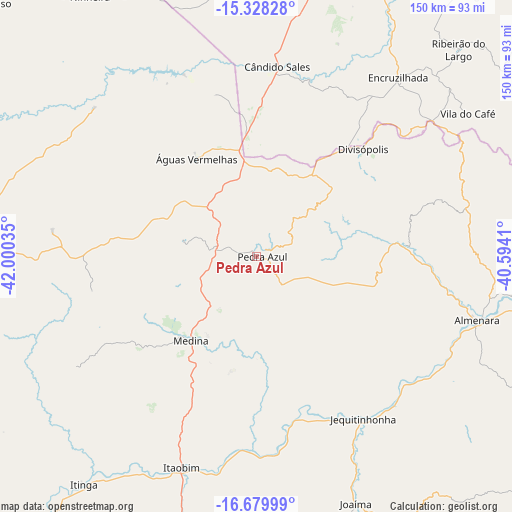
Pedra Azul GPS coordinates[2]
16° 0' 19.008" South, 41° 17' 49.992" West
| Map corner | latitude | longitude |
|---|---|---|
| Upper-left | -15.32828°, | -42.00035° |
| Center: | -16.00528°, | -41.29722° |
| Lower-right: | -16.67999°, | -40.5941° |
| Map W x H: | 150.3×150.3 km | = 93.4×93.4mi |
| max Lat: | 2.81972° ⇑46.6% North |
| Pedra Azul: | -16.00528° |
| min Lat: | ⇓53.4% South -33.69111° |
| min Long | Pedra Azul | max Long |
| -72.89583° | -41.29722° | -32.41083° |
| W 69.1%⇐ | ⇒30.9% E |
Elevation
Elevation of Pedra Azul is 678 m = 2224 ft, and this is 297.1 m = 975 ft above average elevation for this country.
| Max E: |
1603 m = 5259 ft | 21% |
| Pedra Azul | 678 m 2224 ft | |
| Avg. | 380.9 m = 1250 ft | |
Min E: |
0 m = 0 ft | 79% |
See also: Brazil elevation on elevation.city.
Geographical zone
Pedra Azul is located in South Torrid zone (between Equator and Tropic of Capricorn). Distance of this Southern Tropic circle is 826.3 km =513.4 mi to South.| Distance of | km | miles | from Pedra Azul |
|---|---|---|---|
| Equator | 1779.6 | 1105.8 | to North |
| Tropic Capricorn | 826.3 | 513.4 | to South |
| Antarctic Circle | 5621.6 | 3493.1 | to South |
| South Pole | 8227.4 | 5112.3 | to South |


Nearby cities:
15 places around Pedra Azul: (largest is in red/bold)
• Almenara
67.4 km =41.9 mi,  107°
107°
• Araçuaí
125 km =77.7 mi,  221°
221°
• Encruzilhada
67.1 km =41.7 mi,  38°
38°
• Itambé
111.1 km =69 mi, 40°
• Itinga
84 km =52.2 mi, 216°
• Jequitinhonha
57.1 km =35.5 mi,  146°
146°
• Joaíma
77.6 km =48.2 mi,  158°
158°
• Medina
30.9 km =19.2 mi, 218°
• Padre Paraíso
120.5 km =74.9 mi,  189°
189°
• Salinas
107.7 km =66.9 mi,  260°
260°
• São João do Paraíso
108.7 km =67.5 mi,  315°
315°
• Taiobeiras
102.5 km =63.7 mi,  282°
282°
• Tremedal
115.1 km =71.5 mi,  353°
353°
• Águas Formosas
125.8 km =78.2 mi, 162°
• Águas Vermelhas
33.6 km =20.9 mi,  328°
328°
Sources, notices
• [Note1] Compared only with cities in Brazil existing in our database
• [Src1] Map data: © OpenStreetMap contributors (CC-BY-SA)
• [Src2] Other city data from geonames.org with taken over terms of usage.
• [Src3] Geographical zone / Annual Mean Temperature by Robert A. Rohde @ Wikipedia
