Birigui geodata
Birigui (São Paulo) is a populated place; located in Brazil in America/Sao_Paulo (GMT-3) time zone. With population of 102,277 people, there are 221 cities with bigger population in this country. Compared to other cities in Brazil, 65.3% of cities are located further ↑North; 79.6% of cities are located further →East and 54% of cities have lower elevation than Birigui. Note1


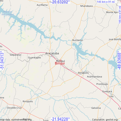
Birigui GPS coordinates[2]
21° 17' 18.996" South, 50° 20' 24" West
| Map corner | latitude | longitude |
|---|---|---|
| Upper-left | -20.63202°, | -51.04313° |
| Center: | -21.28861°, | -50.34° |
| Lower-right: | -21.94228°, | -49.63688° |
| Map W x H: | 145.7×145.7 km | = 90.5×90.5mi |
| max Lat: | 2.81972° ⇑65.3% North |
| Birigui: | -21.28861° |
| min Lat: | ⇓34.7% South -33.69111° |
| min Long | Birigui | max Long |
| -72.89583° | -50.34° | -32.41083° |
| W 20.4%⇐ | ⇒79.6% E |
Elevation
Elevation of Birigui is 409 m = 1342 ft, and this is 28.1 m = 92 ft above average elevation for this country.
| Max E: |
1603 m = 5259 ft | 46% |
| Birigui | 409 m 1342 ft | |
| Avg. | 380.9 m = 1250 ft | |
Min E: |
0 m = 0 ft | 54% |
See also: Birigui elevation on elevation.city.
Geographical zone
Birigui is located in South Torrid zone (between Equator and Tropic of Capricorn). Distance of this Southern Tropic circle is 238.8 km =148.4 mi to South.| Distance of | km | miles | from Birigui |
|---|---|---|---|
| Equator | 2367.1 | 1470.8 | to North |
| Tropic Capricorn | 238.8 | 148.4 | to South |
| Antarctic Circle | 5034.1 | 3128 | to South |
| South Pole | 7640 | 4747.3 | to South |


Nearby cities:
15 places around Birigui: (largest is in red/bold)
• Araçatuba
13.1 km =8.1 mi,  312°
312°
• Auriflama
70.7 km =43.9 mi,  341°
341°
• Bastos
81.3 km =50.5 mi,  210°
210°
• Buritama
31.8 km =19.8 mi,  38°
38°
• General Salgado
71.2 km =44.2 mi,  358°
358°
• Guararapes
31.5 km =19.6 mi,  275°
275°
• José Bonifácio
72.5 km =45 mi,  68°
68°
• Lins
75.5 km =46.9 mi,  125°
125°
• Mirandopólis
80.8 km =50.2 mi, 282°
• Nhandeara
73.5 km =45.7 mi,  25°
25°
• Osvaldo Cruz
79.3 km =49.3 mi,  224°
224°
• Penápolis
30.8 km =19.1 mi,  118°
118°
• Promissão
57 km =35.4 mi, 118°
• Tupã
74 km =46 mi,  194°
194°
• Valparaíso
55.2 km =34.3 mi, 277°
Sources, notices
• [Note1] Compared only with cities in Brazil existing in our database
• [Src1] Map data: © OpenStreetMap contributors (CC-BY-SA)
• [Src2] Other city data from geonames.org with taken over terms of usage.
• [Src3] Geographical zone / Annual Mean Temperature by Robert A. Rohde @ Wikipedia
