Formosa geodata
Formosa (Goiás) is a populated place; located in Brazil in America/Sao_Paulo (GMT-3) time zone. With population of 81,232 people, there are 284 cities with bigger population in this country. Compared to other cities in Brazil, 54.9% of cities are located further ↓South; 60.4% of cities are located further →East and 96% of cities have lower elevation than Formosa. Note1


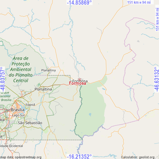
Formosa GPS coordinates[2]
15° 32' 13.992" South, 47° 20' 3.984" West
| Map corner | latitude | longitude |
|---|---|---|
| Upper-left | -14.85869°, | -48.03757° |
| Center: | -15.53722°, | -47.33444° |
| Lower-right: | -16.21352°, | -46.63132° |
| Map W x H: | 150.6×150.6 km | = 93.6×93.6mi |
| max Lat: | 2.81972° ⇑45.1% North |
| Formosa: | -15.53722° |
| min Lat: | ⇓54.9% South -33.69111° |
| min Long | Formosa | max Long |
| -72.89583° | -47.33444° | -32.41083° |
| W 39.6%⇐ | ⇒60.4% E |
Elevation
Elevation of Formosa is 915 m = 3002 ft, and this is 534.1 m = 1752 ft above average elevation for this country.
| Max E: |
1603 m = 5259 ft | 4% |
| Formosa | 915 m 3002 ft | |
| Avg. | 380.9 m = 1250 ft | |
Min E: |
0 m = 0 ft | 96% |
See also: Formosa elevation on elevation.city.
Geographical zone
Formosa is located in South Torrid zone (between Equator and Tropic of Capricorn). Distance of this Southern Tropic circle is 878.3 km =545.8 mi to South.| Distance of | km | miles | from Formosa |
|---|---|---|---|
| Equator | 1727.6 | 1073.5 | to North |
| Tropic Capricorn | 878.3 | 545.8 | to South |
| Antarctic Circle | 5673.6 | 3525.4 | to South |
| South Pole | 8279.5 | 5144.6 | to South |


Nearby cities:
15 places around Formosa: (largest is in red/bold)
• Abadiânia
164.5 km =102.2 mi,  243°
243°
• Arinos
138.1 km =85.8 mi,  107°
107°
• Barro Alto
181 km =112.5 mi,  290°
290°
• Brasília
69.2 km =43 mi,  247°
247°
• Buritis
98 km =60.9 mi,  95°
95°
• Cristalina
140.1 km =87.1 mi,  192°
192°
• Iaciara
177.2 km =110.1 mi,  25°
25°
• Luziânia
103.3 km =64.2 mi,  219°
219°
• Niquelândia
169.1 km =105.1 mi,  314°
314°
• Padre Bernardo
109.7 km =68.2 mi, 292°
• Pirenópolis
177.6 km =110.4 mi,  258°
258°
• Planaltina
31.4 km =19.5 mi, 287°
• Planaltina
34.8 km =21.6 mi, 255°
• Unaí
102.1 km =63.4 mi,  153°
153°
• Vianópolis
184.1 km =114.4 mi, 223°
Sources, notices
• [Note1] Compared only with cities in Brazil existing in our database
• [Src1] Map data: © OpenStreetMap contributors (CC-BY-SA)
• [Src2] Other city data from geonames.org with taken over terms of usage.
• [Src3] Geographical zone / Annual Mean Temperature by Robert A. Rohde @ Wikipedia
