Planaltina geodata
Planaltina (Goiás) is a populated place; located in Brazil in America/Sao_Paulo (GMT-3) time zone. With population of 88,853 people, there are 259 cities with bigger population in this country. Compared to other cities in Brazil, 55.2% of cities are located further ↓South; 62.5% of cities are located further →East and 98.8% of cities have lower elevation than Planaltina. Note1


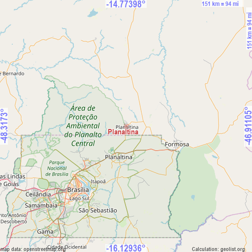
Planaltina GPS coordinates[2]
15° 27' 10.008" South, 47° 36' 51.012" West
| Map corner | latitude | longitude |
|---|---|---|
| Upper-left | -14.77398°, | -48.3173° |
| Center: | -15.45278°, | -47.61417° |
| Lower-right: | -16.12936°, | -46.91105° |
| Map W x H: | 150.7×150.7 km | = 93.6×93.6mi |
| max Lat: | 2.81972° ⇑44.8% North |
| Planaltina: | -15.45278° |
| min Lat: | ⇓55.2% South -33.69111° |
| min Long | Planaltina | max Long |
| -72.89583° | -47.61417° | -32.41083° |
| W 37.5%⇐ | ⇒62.5% E |
Elevation
Elevation of Planaltina is 1038 m = 3406 ft, and this is 657.1 m = 2156 ft above average elevation for this country.
| Max E: |
1603 m = 5259 ft | 1.2% |
| Planaltina | 1038 m 3406 ft | |
| Avg. | 380.9 m = 1250 ft | |
Min E: |
0 m = 0 ft | 98.8% |
See also: Planaltina elevation on elevation.city.
Geographical zone
Planaltina is located in South Torrid zone (between Equator and Tropic of Capricorn). Distance of this Southern Tropic circle is 887.7 km =551.6 mi to South.| Distance of | km | miles | from Planaltina |
|---|---|---|---|
| Equator | 1718.2 | 1067.6 | to North |
| Tropic Capricorn | 887.7 | 551.6 | to South |
| Antarctic Circle | 5683 | 3531.3 | to South |
| South Pole | 8288.9 | 5150.5 | to South |


Nearby cities:
15 places around Planaltina: (largest is in red/bold)
• Abadiânia
143.7 km =89.3 mi,  234°
234°
• Arinos
169.5 km =105.3 mi,  107°
107°
• Barro Alto
149.6 km =93 mi,  290°
290°
• Brasília
49.6 km =30.8 mi,  222°
222°
• Buritis
128.9 km =80.1 mi,  98°
98°
• Cristalina
146.2 km =90.8 mi,  180°
180°
• Formosa
31.4 km =19.5 mi, 107°
• Goianésia
161.9 km =100.6 mi,  275°
275°
• Luziânia
95.9 km =59.6 mi,  202°
202°
• Niquelândia
141.8 km =88.1 mi,  320°
320°
• Padre Bernardo
78.5 km =48.8 mi, 293°
• Pirenópolis
150.8 km =93.7 mi,  252°
252°
• Planaltina
18.7 km =11.6 mi,  191°
191°
• Silvânia
171.1 km =106.3 mi, 218°
• Unaí
125.9 km =78.2 mi,  143°
143°
Sources, notices
• [Note1] Compared only with cities in Brazil existing in our database
• [Src1] Map data: © OpenStreetMap contributors (CC-BY-SA)
• [Src2] Other city data from geonames.org with taken over terms of usage.
• [Src3] Geographical zone / Annual Mean Temperature by Robert A. Rohde @ Wikipedia
