Planaltina geodata
Planaltina (Federal District) is a populated place; located in Brazil in America/Sao_Paulo (GMT-3) time zone. With population of 189,412 people, there are 123 cities with bigger population in this country. Compared to other cities in Brazil, 54.5% of cities are located further ↓South; 62.8% of cities are located further →East and 98.1% of cities have lower elevation than Planaltina. Note1


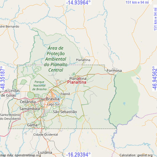
Planaltina GPS coordinates[2]
15° 37' 4.476" South, 47° 38' 55.464" West
| Map corner | latitude | longitude |
|---|---|---|
| Upper-left | -14.93964°, | -48.35187° |
| Center: | -15.61791°, | -47.64874° |
| Lower-right: | -16.29394°, | -46.94562° |
| Map W x H: | 150.6×150.6 km | = 93.6×93.6mi |
| max Lat: | 2.81972° ⇑45.5% North |
| Planaltina: | -15.61791° |
| min Lat: | ⇓54.5% South -33.69111° |
| min Long | Planaltina | max Long |
| -72.89583° | -47.64874° | -32.41083° |
| W 37.2%⇐ | ⇒62.8% E |
Elevation
Elevation of Planaltina is 987 m = 3238 ft, and this is 606.1 m = 1989 ft above average elevation for this country.
| Max E: |
1603 m = 5259 ft | 1.9% |
| Planaltina | 987 m 3238 ft | |
| Avg. | 380.9 m = 1250 ft | |
Min E: |
0 m = 0 ft | 98.1% |
See also: Planaltina elevation on elevation.city.
Geographical zone
Planaltina is located in South Torrid zone (between Equator and Tropic of Capricorn). Distance of this Southern Tropic circle is 869.4 km =540.2 mi to South.| Distance of | km | miles | from Planaltina |
|---|---|---|---|
| Equator | 1736.5 | 1079 | to North |
| Tropic Capricorn | 869.4 | 540.2 | to South |
| Antarctic Circle | 5664.6 | 3519.8 | to South |
| South Pole | 8270.5 | 5139 | to South |


Nearby cities:
15 places around Planaltina: (largest is in red/bold)
• Abadiânia
130.6 km =81.2 mi,  240°
240°
• Anápolis
160.1 km =99.5 mi, 240°
• Barro Alto
153.8 km =95.6 mi,  297°
297°
• Brasília
35 km =21.7 mi, 239°
• Buritis
131.2 km =81.5 mi,  89°
89°
• Cristalina
127.9 km =79.5 mi,  178°
178°
• Formosa
34.8 km =21.6 mi,  75°
75°
• Luziânia
77.6 km =48.2 mi,  204°
204°
• Niquelândia
154.2 km =95.8 mi,  325°
325°
• Padre Bernardo
84.5 km =52.5 mi,  306°
306°
• Pirenópolis
142.8 km =88.7 mi,  259°
259°
• Planaltina
18.7 km =11.6 mi,  11°
11°
• Silvânia
154.6 km =96.1 mi,  221°
221°
• Unaí
114.3 km =71 mi,  136°
136°
• Vianópolis
155.6 km =96.7 mi, 216°
Sources, notices
• [Note1] Compared only with cities in Brazil existing in our database
• [Src1] Map data: © OpenStreetMap contributors (CC-BY-SA)
• [Src2] Other city data from geonames.org with taken over terms of usage.
• [Src3] Geographical zone / Annual Mean Temperature by Robert A. Rohde @ Wikipedia
