Irati geodata
Irati (Paraná) is a populated place; located in Brazil in America/Sao_Paulo (GMT-3) time zone. With population of 45,830 people, there are 465 cities with bigger population in this country. Compared to other cities in Brazil, 88.8% of cities are located further ↑North; 81.2% of cities are located further →East and 92.3% of cities have lower elevation than Irati. Note1


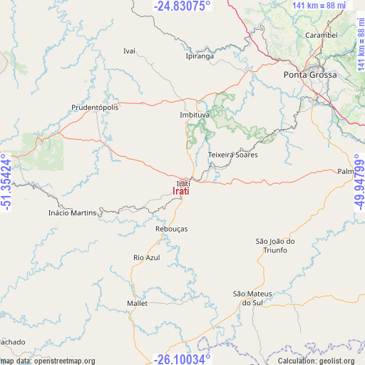
Irati GPS coordinates[2]
25° 28' 1.992" South, 50° 39' 3.996" West
| Map corner | latitude | longitude |
|---|---|---|
| Upper-left | -24.83075°, | -51.35424° |
| Center: | -25.46722°, | -50.65111° |
| Lower-right: | -26.10034°, | -49.94799° |
| Map W x H: | 141.2×141.2 km | = 87.7×87.7mi |
| max Lat: | 2.81972° ⇑88.8% North |
| Irati: | -25.46722° |
| min Lat: | ⇓11.2% South -33.69111° |
| min Long | Irati | max Long |
| -72.89583° | -50.65111° | -32.41083° |
| W 18.8%⇐ | ⇒81.2% E |
Elevation
Elevation of Irati is 848 m = 2782 ft, and this is 467.1 m = 1532 ft above average elevation for this country.
| Max E: |
1603 m = 5259 ft | 7.7% |
| Irati | 848 m 2782 ft | |
| Avg. | 380.9 m = 1250 ft | |
Min E: |
0 m = 0 ft | 92.3% |
See also: Irati elevation on elevation.city.
Geographical zone
Irati is located in South temperate zone (between Tropic of Capricorn and the Antarctic Circle). Distance of this Southern Tropic circle is 225.8 km =140.3 mi to North.| Distance of | km | miles | from Irati |
|---|---|---|---|
| Equator | 2831.7 | 1759.5 | to North |
| Tropic Capricorn | 225.8 | 140.3 | to North |
| Antarctic Circle | 4569.5 | 2839.4 | to South |
| South Pole | 7175.4 | 4458.6 | to South |


Nearby cities:
15 places around Irati: (largest is in red/bold)
• Canoinhas
83.2 km =51.7 mi,  161°
161°
• Carambeí
78.6 km =48.8 mi,  43°
43°
• Castro
99.1 km =61.6 mi, 40°
• Guarapuava
82.2 km =51.1 mi,  275°
275°
• Imbituva
26.8 km =16.7 mi,  10°
10°
• Lapa
99.6 km =61.9 mi,  109°
109°
• Palmeira
64.9 km =40.3 mi,  86°
86°
• Pinhão
104.3 km =64.8 mi,  255°
255°
• Ponta Grossa
64.3 km =40 mi,  49°
49°
• Porto União
95.8 km =59.5 mi,  206°
206°
• Prudentópolis
43.3 km =26.9 mi,  310°
310°
• Reserva
93 km =57.8 mi,  347°
347°
• São Mateus do Sul
52.6 km =32.7 mi,  149°
149°
• Três Barras
78.3 km =48.7 mi, 155°
• União da Vitória
95.3 km =59.2 mi, 207°
Sources, notices
• [Note1] Compared only with cities in Brazil existing in our database
• [Src1] Map data: © OpenStreetMap contributors (CC-BY-SA)
• [Src2] Other city data from geonames.org with taken over terms of usage.
• [Src3] Geographical zone / Annual Mean Temperature by Robert A. Rohde @ Wikipedia
