Prudentópolis geodata
Prudentópolis (Paraná) is a populated place; located in Brazil in America/Sao_Paulo (GMT-3) time zone. With population of 19,611 people, there are 955 cities with bigger population in this country. Compared to other cities in Brazil, 88% of cities are located further ↑North; 82.2% of cities are located further →East and 85.8% of cities have lower elevation than Prudentópolis. Note1


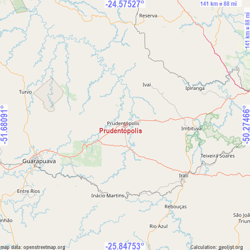
Prudentópolis GPS coordinates[2]
25° 12' 47.016" South, 50° 58' 40.008" West
| Map corner | latitude | longitude |
|---|---|---|
| Upper-left | -24.57527°, | -51.68091° |
| Center: | -25.21306°, | -50.97778° |
| Lower-right: | -25.84753°, | -50.27466° |
| Map W x H: | 141.5×141.5 km | = 87.9×87.9mi |
| max Lat: | 2.81972° ⇑88% North |
| Prudentópolis: | -25.21306° |
| min Lat: | ⇓12% South -33.69111° |
| min Long | Prudentópolis | max Long |
| -72.89583° | -50.97778° | -32.41083° |
| W 17.8%⇐ | ⇒82.2% E |
Elevation
Elevation of Prudentópolis is 765 m = 2510 ft, and this is 384.1 m = 1260 ft above average elevation for this country.
| Max E: |
1603 m = 5259 ft | 14.2% |
| Prudentópolis | 765 m 2510 ft | |
| Avg. | 380.9 m = 1250 ft | |
Min E: |
0 m = 0 ft | 85.8% |
See also: Brazil elevation on elevation.city.
Geographical zone
Prudentópolis is located in South temperate zone (between Tropic of Capricorn and the Antarctic Circle). Distance of this Southern Tropic circle is 197.5 km =122.7 mi to North.| Distance of | km | miles | from Prudentópolis |
|---|---|---|---|
| Equator | 2803.4 | 1742 | to North |
| Tropic Capricorn | 197.5 | 122.7 | to North |
| Antarctic Circle | 4597.7 | 2856.9 | to South |
| South Pole | 7203.6 | 4476.1 | to South |


Nearby cities:
15 places around Prudentópolis: (largest is in red/bold)
• Carambeí
91.5 km =56.9 mi,  71°
71°
• Castro
108.1 km =67.2 mi,  64°
64°
• Cândido de Abreu
80.3 km =49.9 mi,  333°
333°
• Guarapuava
52.8 km =32.8 mi,  248°
248°
• Imbituva
37.6 km =23.4 mi,  92°
92°
• Irati
43.3 km =26.9 mi,  130°
130°
• Ortigueira
111.8 km =69.5 mi,  1°
1°
• Palmeira
100.6 km =62.5 mi,  103°
103°
• Pinhão
87 km =54.1 mi,  231°
231°
• Pitanga
93.8 km =58.3 mi,  302°
302°
• Ponta Grossa
83.2 km =51.7 mi,  80°
80°
• Reserva
63.9 km =39.7 mi,  11°
11°
• São Mateus do Sul
94.7 km =58.8 mi,  140°
140°
• Telêmaco Borba
105.4 km =65.5 mi,  20°
20°
• Tibagi
96.7 km =60.1 mi,  36°
36°
Sources, notices
• [Note1] Compared only with cities in Brazil existing in our database
• [Src1] Map data: © OpenStreetMap contributors (CC-BY-SA)
• [Src2] Other city data from geonames.org with taken over terms of usage.
• [Src3] Geographical zone / Annual Mean Temperature by Robert A. Rohde @ Wikipedia
