Goiás geodata
Goiás is a populated place; located in Brazil in America/Sao_Paulo (GMT-3) time zone. With population of 19,098 people, there are 979 cities with bigger population in this country. Compared to other cities in Brazil, 53.5% of cities are located further ↓South; 78.9% of cities are located further →East and 62% of cities have lower elevation than Goiás. Note1


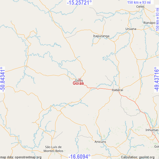
Goiás GPS coordinates[2]
15° 56' 3.984" South, 50° 8' 25.008" West
| Map corner | latitude | longitude |
|---|---|---|
| Upper-left | -15.25721°, | -50.84341° |
| Center: | -15.93444°, | -50.14028° |
| Lower-right: | -16.6094°, | -49.43716° |
| Map W x H: | 150.3×150.4 km | = 93.4×93.5mi |
| max Lat: | 2.81972° ⇑46.5% North |
| Goiás: | -15.93444° |
| min Lat: | ⇓53.5% South -33.69111° |
| min Long | Goiás | max Long |
| -72.89583° | -50.14028° | -32.41083° |
| W 21.1%⇐ | ⇒78.9% E |
Elevation
Elevation of Goiás is 496 m = 1627 ft, and this is 115.1 m = 378 ft above average elevation for this country.
| Max E: |
1603 m = 5259 ft | 38% |
| Goiás | 496 m 1627 ft | |
| Avg. | 380.9 m = 1250 ft | |
Min E: |
0 m = 0 ft | 62% |
See also: Brazil elevation on elevation.city.
Geographical zone
Goiás is located in South Torrid zone (between Equator and Tropic of Capricorn). Distance of this Southern Tropic circle is 834.2 km =518.3 mi to South.| Distance of | km | miles | from Goiás |
|---|---|---|---|
| Equator | 1771.7 | 1100.9 | to North |
| Tropic Capricorn | 834.2 | 518.3 | to South |
| Antarctic Circle | 5629.4 | 3497.9 | to South |
| South Pole | 8235.3 | 5117.2 | to South |


Nearby cities:
15 places around Goiás: (largest is in red/bold)
• Anicuns
61.6 km =38.3 mi,  161°
161°
• Carmo do Rio Verde
79.5 km =49.4 mi,  35°
35°
• Ceres
90.6 km =56.3 mi, 39°
• Firminópolis
74.1 km =46 mi,  193°
193°
• Goianira
98.5 km =61.2 mi,  129°
129°
• Inhumas
83.4 km =51.8 mi,  124°
124°
• Itaberaí
36.5 km =22.7 mi,  105°
105°
• Itapirapuã
52.1 km =32.4 mi,  283°
283°
• Itapuranga
46.2 km =28.7 mi,  26°
26°
• Jaraguá
88.4 km =54.9 mi,  77°
77°
• Petrolina de Goiás
87.6 km =54.4 mi,  101°
101°
• Rialma
91 km =56.5 mi, 40°
• Rubiataba
92.9 km =57.7 mi,  22°
22°
• São Luís de Montes Belos
70.2 km =43.6 mi,  200°
200°
• Uruana
68.5 km =42.6 mi,  45°
45°
Sources, notices
• [Note1] Compared only with cities in Brazil existing in our database
• [Src1] Map data: © OpenStreetMap contributors (CC-BY-SA)
• [Src2] Other city data from geonames.org with taken over terms of usage.
• [Src3] Geographical zone / Annual Mean Temperature by Robert A. Rohde @ Wikipedia
