Santo Antônio do Leverger geodata
Santo Antônio do Leverger (Mato Grosso) is a populated place; located in Brazil in America/Cuiaba (GMT-4) time zone. With population of 6,387 people, there are 1864 cities with bigger population in this country. Compared to other cities in Brazil, 53.8% of cities are located further ↓South; 95.3% of cities are located further →East and 67.3% of cities have higher elevation than Santo Antônio do Leverger. Note1
Current local time in Santo Antônio do Leverger:
12:02 AM, WednesdayDifference from your time zone: hours


Santo Antônio do Leverger GPS coordinates[2]
15° 51' 56.016" South, 56° 4' 36.012" West
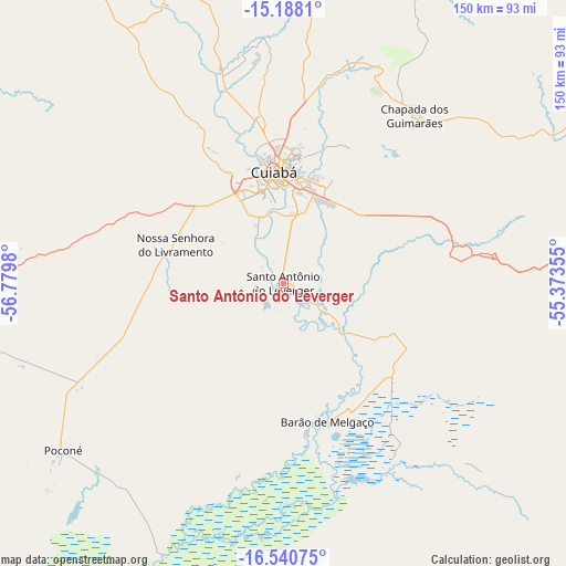
| Map corner | latitude | longitude |
|---|---|---|
| Upper-left | -15.1881°, | -56.7798° |
| Center: | -15.86556°, | -56.07667° |
| Lower-right: | -16.54075°, | -55.37355° |
| Map W x H: | 150.4×150.4 km | = 93.5×93.5mi |
| max Lat: | 2.81972° ⇑46.2% North |
| Santo Antônio do Leverger: | -15.86556° |
| min Lat: | ⇓53.8% South -33.69111° |
| min Long | Santo Antônio | max Long |
| -72.89583° | -56.07667° | -32.41083° |
| W 4.7%⇐ | ⇒95.3% E |
Elevation
Elevation of Santo Antônio do Leverger is 150 m = 492 ft, and this is 230.9 m = 758 ft below average elevation for this country.
| Max E: |
1603 m = 5259 ft | 67.3% |
| Avg. | 380.9 m = 1250 ft | |
| Santo Antônio do Leverger | 150 m = 492 ft | |
Min E: |
0 m = 0 ft | 32.7% |
See also: Brazil elevation on elevation.city.
Geographical zone
Santo Antônio do Leverger is located in South Torrid zone (between Equator and Tropic of Capricorn). Distance of this Southern Tropic circle is 841.8 km =523.1 mi to South.| Distance of | km | miles | from Santo Antônio do Leverger |
|---|---|---|---|
| Equator | 1764.1 | 1096.2 | to North |
| Tropic Capricorn | 841.8 | 523.1 | to South |
| Antarctic Circle | 5637.1 | 3502.7 | to South |
| South Pole | 8243 | 5122 | to South |


Nearby cities:
15 places around Santo Antônio do Leverger: (largest is in red/bold)
• Arenápolis
177.7 km =110.4 mi,  332°
332°
• Barra do Bugres
147.6 km =91.7 mi,  306°
306°
• Barão de Melgaço
38.4 km =23.9 mi,  162°
162°
• Chapada dos Guimarães
57 km =35.4 mi,  37°
37°
• Cuiabá
30 km =18.6 mi,  355°
355°
• Diamantino
166.8 km =103.6 mi,  346°
346°
• Jaciara
119 km =73.9 mi,  95°
95°
• Lucas
54.2 km =33.7 mi, 163°
• Nobres
130.2 km =80.9 mi, 348°
• Nortelândia
175.2 km =108.9 mi, 333°
• Nova Olímpia
176 km =109.4 mi, 312°
• Poconé
72.8 km =45.2 mi,  233°
233°
• Rondonópolis
168 km =104.4 mi,  113°
113°
• Rosário Oeste
120.5 km =74.9 mi,  341°
341°
• Várzea Grande
25.1 km =15.6 mi, 346°
Sources, notices
• [Note1] Compared only with cities in Brazil existing in our database
• [Src1] Map data: © OpenStreetMap contributors (CC-BY-SA)
• [Src2] Other city data from geonames.org with taken over terms of usage.
• [Src3] Geographical zone / Annual Mean Temperature by Robert A. Rohde @ Wikipedia
