Pontes e Lacerda geodata
Pontes e Lacerda (Mato Grosso) is a populated place; located in Brazil in America/Cuiaba (GMT-4) time zone. With population of 29,381 people, there are 680 cities with bigger population in this country. Compared to other cities in Brazil, 55.7% of cities are located further ↓South; 97.1% of cities are located further →East and 56.8% of cities have higher elevation than Pontes e Lacerda. Note1


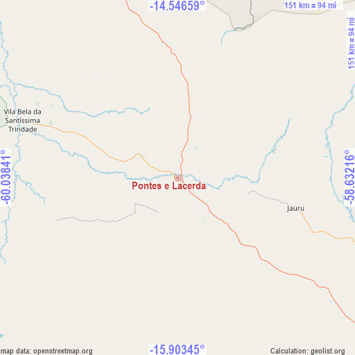
Pontes e Lacerda GPS coordinates[2]
15° 13' 33.996" South, 59° 20' 7.008" West
| Map corner | latitude | longitude |
|---|---|---|
| Upper-left | -14.54659°, | -60.03841° |
| Center: | -15.22611°, | -59.33528° |
| Lower-right: | -15.90345°, | -58.63216° |
| Map W x H: | 150.9×150.9 km | = 93.8×93.8mi |
| max Lat: | 2.81972° ⇑44.3% North |
| Pontes e Lacerda: | -15.22611° |
| min Lat: | ⇓55.7% South -33.69111° |
| min Long | Pontes e Lacerd | max Long |
| -72.89583° | -59.33528° | -32.41083° |
| W 2.9%⇐ | ⇒97.1% E |
Elevation
Elevation of Pontes e Lacerda is 247 m = 810 ft, and this is 133.9 m = 439 ft below average elevation for this country.
| Max E: |
1603 m = 5259 ft | 56.8% |
| Avg. | 380.9 m = 1250 ft | |
| Pontes e Lacerda | 247 m = 810 ft | |
Min E: |
0 m = 0 ft | 43.2% |
See also: Brazil elevation on elevation.city.
Geographical zone
Pontes e Lacerda is located in South Torrid zone (between Equator and Tropic of Capricorn). Distance of this Southern Tropic circle is 912.9 km =567.2 mi to South.| Distance of | km | miles | from Pontes e Lacerda |
|---|---|---|---|
| Equator | 1693 | 1052 | to North |
| Tropic Capricorn | 912.9 | 567.2 | to South |
| Antarctic Circle | 5708.2 | 3546.9 | to South |
| South Pole | 8314.1 | 5166.1 | to South |


Nearby cities:
15 places around Pontes e Lacerda: (largest is in red/bold)
• Arenápolis
281.1 km =174.7 mi,  72°
72°
• Barra do Bugres
231.8 km =144 mi,  85°
85°
• Barão de Melgaço
376.2 km =233.8 mi,  106°
106°
• Chapada dos Guimarães
385.3 km =239.4 mi, 93°
• Cuiabá
349.6 km =217.2 mi,  96°
96°
• Diamantino
323.6 km =201.1 mi, 73°
• Lucas
384.3 km =238.8 mi, 108°
• Nobres
327.9 km =203.7 mi,  80°
80°
• Nortelândia
285.4 km =177.3 mi, 72°
• Nova Olímpia
225 km =139.8 mi, 77°
• Poconé
312.1 km =193.9 mi, 111°
• Rosário Oeste
315.2 km =195.9 mi, 82°
• Santo Antônio do Leverger
356.2 km =221.3 mi, 101°
• Vilhena
289.9 km =180.1 mi,  342°
342°
• Várzea Grande
346.4 km =215.2 mi, 97°
Sources, notices
• [Note1] Compared only with cities in Brazil existing in our database
• [Src1] Map data: © OpenStreetMap contributors (CC-BY-SA)
• [Src2] Other city data from geonames.org with taken over terms of usage.
• [Src3] Geographical zone / Annual Mean Temperature by Robert A. Rohde @ Wikipedia
