Jaciara geodata
Jaciara (Mato Grosso) is a populated place; located in Brazil in America/Cuiaba (GMT-4) time zone. With population of 22,737 people, there are 841 cities with bigger population in this country. Compared to other cities in Brazil, 53.4% of cities are located further ↓South; 94.4% of cities are located further →East and 50.8% of cities have lower elevation than Jaciara. Note1


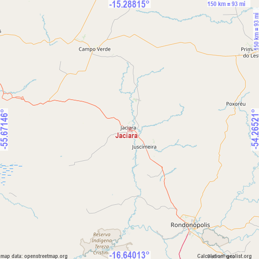
Jaciara GPS coordinates[2]
15° 57' 55.008" South, 54° 58' 5.988" West
| Map corner | latitude | longitude |
|---|---|---|
| Upper-left | -15.28815°, | -55.67146° |
| Center: | -15.96528°, | -54.96833° |
| Lower-right: | -16.64013°, | -54.26521° |
| Map W x H: | 150.3×150.3 km | = 93.4×93.4mi |
| max Lat: | 2.81972° ⇑46.6% North |
| Jaciara: | -15.96528° |
| min Lat: | ⇓53.4% South -33.69111° |
| min Long | Jaciara | max Long |
| -72.89583° | -54.96833° | -32.41083° |
| W 5.6%⇐ | ⇒94.4% E |
Elevation
Elevation of Jaciara is 362 m = 1188 ft, and this is 18.9 m = 62 ft below average elevation for this country.
| Max E: |
1603 m = 5259 ft | 49.2% |
| Avg. | 380.9 m = 1250 ft | |
| Jaciara | 362 m = 1188 ft | |
Min E: |
0 m = 0 ft | 50.8% |
See also: Brazil elevation on elevation.city.
Geographical zone
Jaciara is located in South Torrid zone (between Equator and Tropic of Capricorn). Distance of this Southern Tropic circle is 830.7 km =516.2 mi to South.| Distance of | km | miles | from Jaciara |
|---|---|---|---|
| Equator | 1775.2 | 1103.1 | to North |
| Tropic Capricorn | 830.7 | 516.2 | to South |
| Antarctic Circle | 5626 | 3495.8 | to South |
| South Pole | 8231.9 | 5115.1 | to South |


Nearby cities:
15 places around Jaciara: (largest is in red/bold)
• Alto Araguaia
239.6 km =148.9 mi,  128°
128°
• Barra do Bugres
257 km =159.7 mi,  292°
292°
• Barão de Melgaço
109.7 km =68.2 mi,  256°
256°
• Chapada dos Guimarães
100.7 km =62.6 mi,  303°
303°
• Cuiabá
127.5 km =79.2 mi, 288°
• Diamantino
234.7 km =145.8 mi,  317°
317°
• Guiratinga
135.6 km =84.3 mi,  108°
108°
• Lucas
110.9 km =68.9 mi,  248°
248°
• Nobres
201 km =124.9 mi,  313°
313°
• Poconé
179.7 km =111.7 mi, 259°
• Poxoréo
63.5 km =39.5 mi,  77°
77°
• Rondonópolis
66.5 km =41.3 mi,  147°
147°
• Rosário Oeste
200.6 km =124.6 mi, 308°
• Santo Antônio do Leverger
119 km =73.9 mi,  275°
275°
• Várzea Grande
129.5 km =80.5 mi, 285°
Sources, notices
• [Note1] Compared only with cities in Brazil existing in our database
• [Src1] Map data: © OpenStreetMap contributors (CC-BY-SA)
• [Src2] Other city data from geonames.org with taken over terms of usage.
• [Src3] Geographical zone / Annual Mean Temperature by Robert A. Rohde @ Wikipedia
